SATURDAY - Once again our untrustworthy Garmin RV 770 LMT-S GPS failed to safely guide us to our destination.
It routed us through the Cedar Falls Trailhead parking lot within the Hocking Hills State Park, which is located nowhere near the campground entrance to the park. I know what you're all probably thinking, I need to be more specific when creating my destination request. Wrong!
I always zoom into our exact campsite driveway on Google Maps and grab the GPS coordinates of that location. Then ask the GPS to route us from the campsite where we are sitting at the moment to those GPS cooridinates, I can't get much more specific than that.
Others are probably thinking, why don't I just use Google Maps or Apple Maps to route us to our destinations? At least in today's case, those too would have sent us down gravel roads that do not exist. One is now a fire maintenance road that is closed to non-emergency use and the other simply does not exist at all.
A half mile further down the road from where the GPS had us turn is the correct entrance to the campground and another quarter mile down the road is the entrance to the Visitor Center. This is not a new problem! There are 33 reviews on the Campendium website for this campground and I found people reporting the same problem we had all the way back to 2016 when the website was first developed.
Today could have been a total disaster if there wasn't a loop at the end of the trailhead parking lot that I was able to get turned around to exit the parking lot. I'm not sure what we would have done if that wasn't the case.
We were warned in our reservation confimation email that there would be absolutely no campground check-ins until after 3:00PM, so we arrived at 3:10PM. Usually the reason for this rule is so there is ample time for the camphosts to cleanup campsites after the 1:00PM check-out time. That's not the reason for the rule here!
Once you stop at the Gatehouse to gain access to the campground there is a narrow and winding half mile long road that leads up a very steep hill to the campground loops. To eliminate the chance of two trailers trying to pass each other, one going out while the other coming in, on this short stretch they maintain the stict 3:00PM check-in time.
To maintain a safe distance between the long drop off on the shoulder of the road on the winding curves, anyone towing a trailer requires at least 1½ of the 2 lanes of the roadway. We passed two small cars heading down the hill while we were coming up the hill and found that to be challenging enough.
Once we arrived at our campsite we had no problem fitting in, but as you can see in the photos it was very unlevel front to back and we had to put the tongue of the trailer almost on the ground.
When I first saw this photo I though something was wrong with Tricia's new camera phone.
Nope! It's just smoke from our neighbor's poor attempt at a campfire.
MONDAY - After taking a day off from any outdoor activities we're hoping the weekend crowds will have left and made for a more pleasurable hike along the parks extensive trail system.
Today we're going to hike the three most recommended trails in the park. They are all short, one mile or less, but have 150+ feet of elevation change because they all decend down into a gorge and then return to the top.
First up is the most visited trail in the park, the 1-mile loop Old Man's Cave Trail. It starts and ends at the Visitor Center, probably why it's the most popular, and there are two entrance points so you can make it just a ½-mile loop if you want to.
We messed up and instead of us doing a 1-mile loop, we made it more of a figure-eight hike with two ½-mile loops.
I should also mention at this point that the trail is One-Way only, because on the weekends this trail is packed with hikers and it makes the flow of people through the gorge much less complicated.
OLD MAN'S CAVE TRAIL
SLIDE NUMBER
1
OF
30
By 9:15 AM we were just starting our hiking adventures for the day.
SLIDE NUMBER
2
OF
30
Immediately we began our decent down into the gorge.
SLIDE NUMBER
3
OF
30
We had to use our imaginations to "visualize" the water flowing over the rocks.
SLIDE NUMBER
4
OF
30
This place would be even more spectacular during the spring snowmelt.
SLIDE NUMBER
5
OF
30
The floor of the gorge would then be filled with flowing water.
SLIDE NUMBER
6
OF
30
The trail was all well marked.
SLIDE NUMBER
7
OF
30
Little signs informed you when you were going the wrong way.
SLIDE NUMBER
8
OF
30
This spot was interesting with a floating stairstep bridge on the gorge floor and a massive A-frame bridge above spanning the width of the gorge.
SLIDE NUMBER
9
OF
30
It was fun walking up and over the floating stairstep bridge.
SLIDE NUMBER
10
OF
30
High up above was the A-frame bridge.
SLIDE NUMBER
11
OF
30
The climate in the gorge (dark-warm-moist) must be perfect for growing mushrooms.
SLIDE NUMBER
12
OF
30
I believe that sign up ahead will tell us we've reached The Old Man's Cave.
SLIDE NUMBER
13
OF
30
Sure enough, we've reached the turn off for the main attraction.
SLIDE NUMBER
14
OF
30
First we'll have to take a short trip underground, no it's not the cave.
SLIDE NUMBER
15
OF
30
It's just a short manmade tunnel to get to the other side of the gorge...
SLIDE NUMBER
16
OF
30
...where there is a gorgeous CCC built stone bridge to cross.
SLIDE NUMBER
17
OF
30
Next, another short tunnel through the rock before...
SLIDE NUMBER
18
OF
30
...we begin our climb up to Old Man's Cave.
SLIDE NUMBER
19
OF
30
This is Old Man's Cave, I think it's more of just an overhang though.
SLIDE NUMBER
20
OF
30
It's nothing like all the other "cave" tours we've been on.
SLIDE NUMBER
21
OF
30
Now it's time to climb back up to the rim where the Visitor Center is.
SLIDE NUMBER
22
OF
30
There's me walking out onto the long A-frame Bridge.
SLIDE NUMBER
23
OF
30
Lookin down into the gorge we just hiked from the A-frame bridge deck.
SLIDE NUMBER
24
OF
30
One last look at the bridge.
SLIDE NUMBER
25
OF
30
This is the upper part of the loop we missed by accidentally starting in the middle.
SLIDE NUMBER
26
OF
30
Again we imagined just how beautiful this would be with water flowing over the falls.
SLIDE NUMBER
27
OF
30
This is called the Devil's Bathtub were the water swirls around before heading downstream.
SLIDE NUMBER
28
OF
30
More stairs chiseled out of the rock to make the trail safer and easier to hike.
SLIDE NUMBER
29
OF
30
One of the more "modern" concrete bridges along the trail.
SLIDE NUMBER
30
OF
30
All done! Time to climb our way out of here one more time.
With one cave trail done it's time to head to the other side of the park where we'll find our second hike of the day.
This one is shorter, just a ½-mile loop, or it can be done as a wheelchair accessible out-and-back trail that is ¼-mile each way.
ASH CAVE TRAIL
SLIDE NUMBER
1
OF
13
The trail starts off with all the warning and informational signs.
SLIDE NUMBER
2
OF
13
The trail out to the cave site is all a paved sidewalk and fairly level.
SLIDE NUMBER
3
OF
13
Instead of climbing down into the gorge it rises up all around you.
SLIDE NUMBER
4
OF
13
More mushrooms, but these look a little different than the others we saw earlier.
SLIDE NUMBER
5
OF
13
Soon we were approaching Ash Cave, named after all the ashes they found here.
SLIDE NUMBER
6
OF
13
Again I have a hard time calling this a cave, but that's what the locals call it.
SLIDE NUMBER
7
OF
13
This one had names carved into the sandstone dating back to the 1860s (and the 1990s).
SLIDE NUMBER
8
OF
13
This is the end of the wheelchair path, but it still has a 180° view of the cave.
SLIDE NUMBER
9
OF
13
To make it a loop trail you'll have to climb out the far side of the cave.
SLIDE NUMBER
10
OF
13
This cave is twice the size of the one we saw earlier this morning.
SLIDE NUMBER
11
OF
13
Looking back one more time before we leave.
SLIDE NUMBER
12
OF
13
Is that a bench I see up there, yippie!
SLIDE NUMBER
13
OF
13
That was a lot of stairs to climb to get up onto the rim. From here it's a slight downhill walk back to the parking lot.
That's enough hiking for this morning, besides it's lunchtime now.
We headed back to THE POD for lunch, there is a lodge here in the park with a restaurant but we've got plenty to eat in the refrigerator.
After a short break for lunch we once again loaded up into the truck and headed to another corner of the park to find our next trail hike.
This one is called the Rock House Trail and once you see the photos you'll understand why.
ROCK HOUSE TRAIL
SLIDE NUMBER
1
OF
30
Let's start this slideshow with a splash of some fall colors we parked ROVER under.
SLIDE NUMBER
2
OF
30
This giant tree was uprooted and toppled over into the gorge.
SLIDE NUMBER
3
OF
30
Down there somewhere is the Rock House.
SLIDE NUMBER
4
OF
30
Let's go find it!
SLIDE NUMBER
5
OF
30
Nothing yet.
SLIDE NUMBER
6
OF
30
This looks a little promising.
SLIDE NUMBER
7
OF
30
Nope, that's not it.
SLIDE NUMBER
8
OF
30
The formation we're looking for it much larger than that.
SLIDE NUMBER
9
OF
30
There were these green ferns growing all over the rockface down here.
SLIDE NUMBER
10
OF
30
See what I mean?
SLIDE NUMBER
11
OF
30
There's some big opening back in there, but no way in that I see.
SLIDE NUMBER
12
OF
30
There's a window into the house up there, but still no way in.
SLIDE NUMBER
13
OF
30
And still other window of the house.
SLIDE NUMBER
14
OF
30
We're obviously not the first people to explore this place.
SLIDE NUMBER
15
OF
30
Finally, the "front door" of the Rock House.
SLIDE NUMBER
16
OF
30
I knew it was going to be huge in here, but I wasn't prepared for this.
SLIDE NUMBER
17
OF
30
Looking back towards that first window we saw.
SLIDE NUMBER
18
OF
30
Looks like maybe I could have fit through if I climbed up the side of the cliff.
SLIDE NUMBER
19
OF
30
The windows all look different from the inside of the house.
SLIDE NUMBER
20
OF
30
We no longer have the whole place to ourselves.
SLIDE NUMBER
21
OF
30
This place is just stunning.
SLIDE NUMBER
22
OF
30
You'll never find a piece of glass that shape to be able to close that window.
SLIDE NUMBER
23
OF
30
It's starting to get a little crowed in here, let's go.
SLIDE NUMBER
24
OF
30
Looking from the side you can't even see the windows.
SLIDE NUMBER
25
OF
30
This is just one of the many current residents of the Rock House.
SLIDE NUMBER
26
OF
30
This looks to be the 3rd generation of bridges over this pool of water.
SLIDE NUMBER
27
OF
30
This is all that's left of the 1st generation of bridges located here.
SLIDE NUMBER
28
OF
30
Again, imagine this with a waterfall flowing over the edge.
SLIDE NUMBER
29
OF
30
That's a long way up to climb out of here...
SLIDE NUMBER
30
OF
30
...but we made it out. More fall colors from the parking lot.


 By 9:15 AM we were just starting our hiking adventures for the day.
 Immediately we began our decent down into the gorge.
 We had to use our imaginations to "visualize" the water flowing over the rocks.
 This place would be even more spectacular during the spring snowmelt.
 The floor of the gorge would then be filled with flowing water.
 The trail was all well marked.
 Little signs informed you when you were going the wrong way.
 This spot was interesting with a floating stairstep bridge on the gorge floor
 It was fun walking up and over the floating stairstep bridge.
 High up above was the A-frame bridge.
 The climate in the gorge (dark-warm-moist) must be perfect for growing mushrooms.
 I believe that sign up ahead will tell us we've reached The Old Man's Cave.
 Sure enough, we've reached the turn off for the main attraction.
 First we'll have to take a short trip underground, no it's not the cave.
 It's just a short manmade tunnel to get to the other side of the gorge...
 ...where there is a gorgeous CCC built stone bridge to cross.
 Next, another short tunnel through the rock before...
 ...we begin our climb up to Old Man's Cave.
 This is Old Man's Cave, I think it's more of just an overhang though.
 It's nothing like all the other "cave" tours we've been on.
 Now it's time to climb back up to the rim where the Visitor Center is.
 There's me walking out onto the long A-frame Bridge.
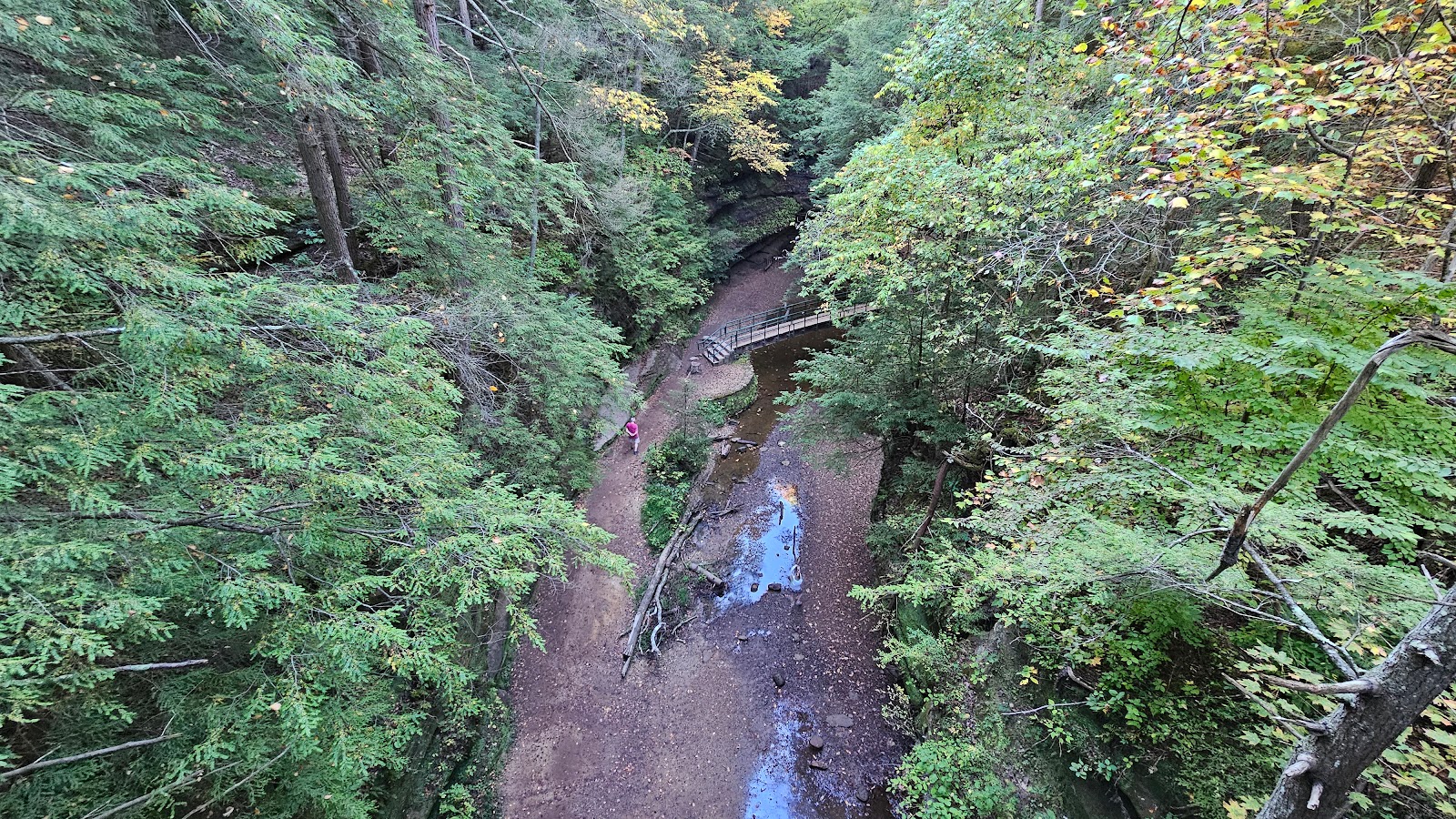 Lookin down into the gorge we just hiked from the A-frame bridge deck.
 One last look at the bridge.
 This is the upper part of the loop we missed by accidentally starting in the middle.
 Again we imagined just how beautiful this would be with water flowing over the falls.
 This is called the Devil's Bathtub were the water swirls around before heading downstream.
 More stairs chiseled out of the rock to make the trail safer and easier to hike.
 One of the more "modern" concrete bridges along the trail.
 All done! Time to climb our way out of here one more time.

 The trail starts off with all the warning and informational signs.
 The trail out to the cave site is all a paved sidewalk and fairly level.
 Instead of climbing down into the gorge it rises up all around you.
 More mushrooms, but these look a little different than the others we saw earlier.
 Soon we were approaching Ash Cave, named after all the ashes they found here.
 Again I have a hard time calling this a cave, but that's what the locals call it.
 This one had names carved into the sandstone dating back to the 1860s (and the 1990s).
 This is the end of the wheelchair path, but it still has a 180° view of the cave.
 To make it a loop trail you'll have to climb out the far side of the cave.
 This cave is twice the size of the one we saw earlier this morning.
 Looking back one more time before we leave.
 Is that a bench I see up there, yippie!
 That was a lot of stairs to climb to get up onto the rim.

 Let's start this slideshow with a splash of some fall colors we parked ROVER under.
 This giant tree was uprooted and toppled over into the gorge.
 Down there somewhere is the Rock House.
 Let's go find it!
 Nothing yet.
 This looks a little promising.
 Nope, that's not it.
 The formation we're looking for it much larger than that.
 There were these green ferns growing all over the rockface down here.
 See what I mean?
 There's some big opening back in there, but no way in that I see.
 There's a window into the house up there, but still no way in.
 And still other window of the house.
 We're obviously not the first people to explore this place.
 Finally, the "front door" of the Rock House.
 I knew it was going to be huge in here, but I wasn't prepared for this.
 Looking back towards that first window we saw.
 Looks like maybe I could have fit through if I climbed up the side of the cliff.
 The windows all look different from the inside of the house.
 We no longer have the whole place to ourselves.
 This place is just stunning.
 You'll never find a piece of glass that shape to be able to close that window.
 It's starting to get a little crowed in here, let's go.
 Looking from the side you can't even see the windows.
 This is just one of the many current residents of the Rock House.
 This looks to be the 3rd generation of bridges over this pool of water.
 This is all that's left of the 1st generation of bridges located here.
 Again, imagine this with a waterfall flowing over the edge.
 That's a long way up to climb out of here...
 ...but we made it out. More fall colors from the parking lot.