
Showing posts with label ARKANSAS. Show all posts

A WEEKEND ON THE ARKANSAS RIVER


THURSDAY - When we were dumping our tanks in the campground this morning Tricia noticed that one of the tires on the driver's side was wearing more rapidly than the other three.

The two inside rows of tread are all but gone on this tire, meaning the alignment of that tire is probably way off. I estimate we have over 30,000 miles on this set of trailer tires. We put them on in September of 2021 and remember, we did go all the way to Alaska and back on them last summer.

We only have 125 miles to travel to our next campsite and I decided we would replace that tire with our brand new matching spare tire when we arrived.


About 75-miles into our drive it was time to start thinking about filling up with gas. All the stations we had passed up to this point were all between $3.39 and $3.49 a gallon. Looking 25-miles ahead using our Gas Buddy app we saw that in the town of DeWitt (pop. 3,292) there were two gas stations both selling at $2.99 a gallon. We decided to wait and fill up there.

While filling with gas I noticed there was a large paved and level empty parking lot across the street that would probably be a better location than a campsite to change a tire. So just 25-miles from our destination we rolled over to the parking lot and began the process of changing the tire on THE POD.


First up, locate all the tools needed for the job (wheel lock key, ¾-inch deep well socket and ¾-inch drive breaker bar, and last but certainly not least is our large ramp we place under the good tandem tire to roll up onto and lift the bad tandem tire off the ground so it can be removed, no jack necessary.

Next we had to locate the key to the lock on our spare tire rack under the front of the trailer. Then drop down the rack and remove the spare tire. This all went off without any problems, thanks to Tricia's previous experience with changing a tire on THE POD.

When we removed the tire we saw that the problem was worse than it first appeared. The steel belts were actually exposed due to the significant wear of the tire. Would it have made it another 25-miles down the road? Probably, but even if it didn't our TPMS (tire pressure monitoring system) would have alerted us to excessive heat or low pressure before we would have been in any danger of an accident.


Just 30-minutes later we were ready to get back on the road, but it's lunchtime and there's a restaurant across the street named "The Catfish Shack" and I'm starting to get hungry.

Always willing to eat out instead of cooking and cleaning, we made our way across the street and enjoyed a delicious lunch. I ordered a pound of deep fried catfish nuggets and Tricia ordered herself some chicken strips.

When we came out of the restaurant we saw this sporty looking truck in the parking lot.
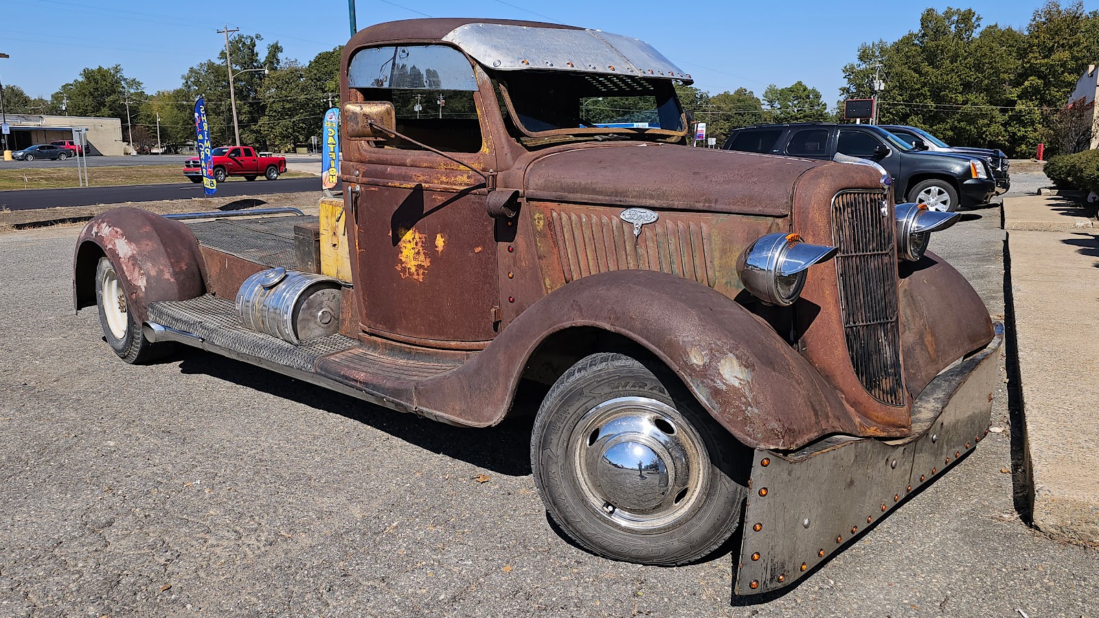
You can even see the parking lot across the street where we changed the tire.

No longer hungry, we pulled back onto the road, but just 5-miles later we were stopped in traffic, waiting for the road crew that was resurfacing the road up ahead. That's a good thing because it needed some work!

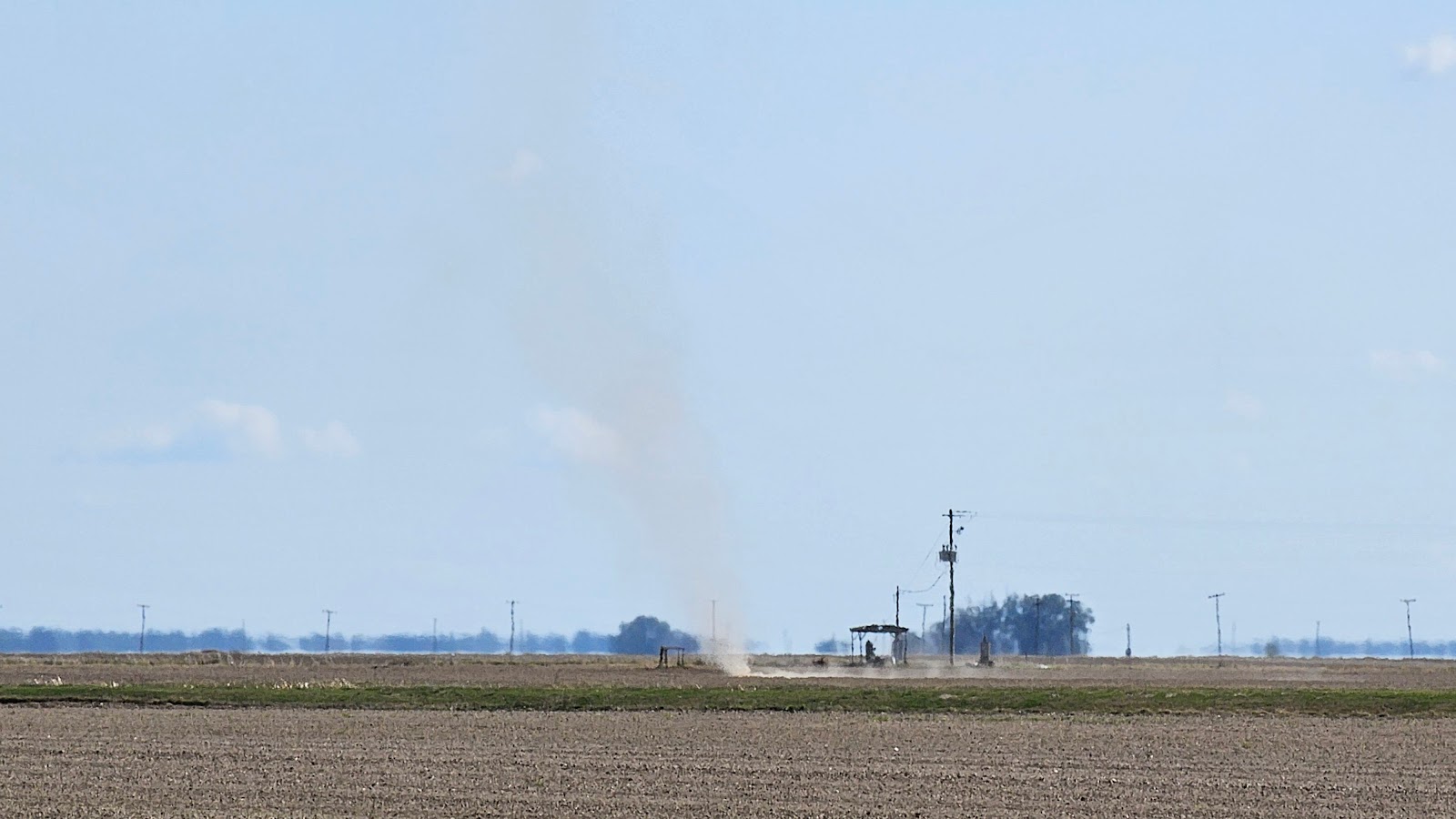
While waiting for the oncoming traffic to clear we had a "dust devil" come spinning it's way across the road right in front of us. Once across the road it made it's way across the field and then just disappeared into thin air, as they say!
At least the final 20-miles of our journey today were uneventful and we arrived at the Pendleton Bend Campground. It's an Army Corp of Engineers park, so we get to camp at half price, just $9 a night for waterfront property with water/electric hookups as a bonus.

From this angle it just looks like your typical campsite.

But from this angle you can see we're right on the banks of the Arkansas River.

Yes, Tricia has already started decorating THE POD for Halloween.

Our first of four sunsets here on the Arkansas River.


SUNDAY - Four years ago, nearly to the day, we camped for two weeks just down river from here at the Merrisach Lake Park in Tichnor, AR.

While we were visiting back in October/November of 2019 we thoroughly explored the surrounding area, including the nearby Arkansas Post National Memorial site.

This time around we're just "Takin' It Easy" and enjoying the view! That doesn't mean we didn't head over to the "Triple P" restaurant to enjoy a Sunday lunch. I was checking out their Facebook Page and was happy to see all the local support they received throughout the whole COVID pandemic and were able keep the business afloat.

This small privately owned and operated restaurant is 10½-miles northeast of the small town of Dumas, AR (pop. 4706) and is situated under the Pendleton Bridge on US-165 that crosses over the Arkansas River. We can easily see the bridge from our campsite!


Would you like to be notified of new blog posts?


VILLAGE CREEK STATE PARK (AR)


TUESDAY - Our Walmart "campsite" was only 13-miles from the Mississippi River bridge that would have us crossing the Tennessee/Missouri border.

This crossing would be our 87th such crossing between states that we haven't done before, that only leaves 20 more to do to have the complete series.

This is not the first, or even the last time that we'll be driving across the Missipssippi River...

..., but it is the first time we've done it between the states of Tennessee and Missouri.


WARNING: If you're not at least a little bit interested in U.S. geography and history you might want to skip this post and rejoin us on the next one!


The area inside the purple outline is called the Missouri Bootheel.

The only reason this border between Tennessee and Missouri exists is because of one man, John Hardeman Walker. Walker was the prominent landowner of the current boot heel region and apparently had enough clout in Washington DC to have his request that his land be part of the new state of Missouri and not that of Arkansas.

In 1820 the State of Missouri was created and the only part of the state that is located south of 36 degrees 30 minutes latitude is the "bootheel" in the southeast corner of the state.

Why do I find this interesting?

If John Hardeman Walker had not had his request approved, we would have had a second "4-corners" location in the United States.

Presently, only the states of UT/CO/AZ/NM meet in one location.

If you move the bottom of the boot heel up to the latitude with the rest of the state, where it was first chosen to be, the states of MO/KY/AR/TN would all meet in the center of the Mississippi River.

Granted, it wouldn't have made such a great tourist location to visit if you wanted just to stand in four states at the same time, which is what the location out west offers to it's visitors.


If you're still reading this I have one more tidbit of geographical oddities to share.

The "Kentucky Bend" is located right in the same general area that we've been looking at.


When the borders of the states of Tennessee and Kentucky were established, the western border of Kentucky was designated as the Mississippi River and it's southwestern border with Tennessee is that same 36 degrees 30 minutes latitude that Arkansas and Missouri used.

Tennessee of course challenged the inclusion of the bend region being part of Kentucky, but in 1848 they eventually dropped their claim.


What do I find interesting about this?

If you want to drive to this bend area of Kentucky, you can't get there from anywhere else in Kentucky, unless you first drive through Tennessee!


If you haven't already guessed it's been a pretty slow "news day" for us.

We're just spending two days here at Village Creek State Park in Arkansas enjoying some down time in this nearly empty campground.

Here are a few campsite photos to hold you over until our next stop.


Would you like to be notified of new blog posts?



DIGGING FOR DIAMONDS


MONDAY

TRAVEL DAY
STOP #239


Today we drove a little over 100 miles due south through the mountains and valleys of the Ouachita National Forest. Early on in the route we found ourselves in a unique position, we were driving our Ford F150, affectionately named ROVER, through a small town in Arkansas coincidentally also named ROVER (pop. 198).

I did a little quick online researching and to the best of my knowledge there are no other towns named ROVER in the United States, so that will most likely never happen again.


Campsite #38 at Crater of Diamonds State Park in Murfreesboro, AR


WEDNESDAY - Today we start our new careers as Diamond Miners!

We woke up early, ate a hearty breakfast, grabbed all of our mining gear and headed towards work. When we arrived we paid our $10 entry fee and joined over a hundred other prospectors hoping to find the next BIG diamond.

Just 18 days ago on October 2nd a woman from California found a 4.38 carat yellow diamond and on Labor Day 2020 a man found a 9.07 carat diamond, the second largest ever found here.

We are going in with no expectations of finding anything so we won't be disappointed when we leave empty handed, like a majority of people do. But it will be a once in a lifetime experience since no where else in the United States can the general public go diamond hunting and get to keep what they find!


I call this next series of photos:

"DIAMOND MINING FOR DUMMIES"


STEP 1 - Find you way to Crater of Diamonds State Park in Murfressboro, AR


STEP 2 - Pay your $10 fee to gain access to the 37-acre diamond field.


STEP 3 - Pick a lucky spot and start digging and filling your bucket.


STEP 4 - Wash all the dirt out of your rocks through a 3-layer process
of ever increasing fine mesh screens hoping to spot something shiny.

If you get real lucky and manage to uncover a large diamond you too could get your name on a 6-foot tall metal shovel with a plaque commemorating the location of your find.

We however did not find anything, as expected, so our names will remain unknown to those who come here in search of diamonds.


The experience was fun, in a hard work kind of way. We spent 4-hours in the field and felt if we were meant to find a diamond it would have happened by now.

There were probably a little over 100 people out spending their Wednesday morning looking for diamonds. We were told that this past weekend saw nearly 2000 people searching each day.

The best part of today was listening to the stories that "the regulars" tell, you know, the ones who come out several times a week to search. Some were very secretive about their methods of searching and some were very eager to share tips on how to increase your chances of actually finding something.

One guy there claimed to have found 10 diamonds of 1-carat or larger over the last 6-years. Another guy drives 11+ hours from northern Illinois about 4 times a year to try his luck. He claimed to have found a bunch of smaller diamonds for a total weight of 23-carats, however most of his finds were 10-points (1/10 of a carat) or less.


We both feel glad that we had the experience of diamond mining, but feel no need to repeat the process anytime in the future. We may have felt differently had we found something valuable!


Would you like to be notified of new blog posts?


We encourage everyone
to leave their comments
in our Facebook Group!


We would really like to hear from you!


Until next time

TWO PEAS


HIGH (UP) IN ARKANSAS


MONDAY

TRAVEL DAY
STOP #238


Today our route is still due south trying to avoid getting caught in the freezing temperatures later this year. Last year we were a little slow in heading south and really paid the price spending a few nights below freezing and in the upper teens. We don't want to make that mistake again!

This weeks camping spot is just a short hike and a few hundred few below the highest point in the state of Arkansas. The summit of Mount Magazine is called Signal Hill and is at an elevation of 2753 feet.

ROVER and THE POD climbed the road leading to the peak of this flat-topped mountain, or mesa, like a champ. Now going back down the other side on our way to the next campground might be a different story if Ford can't find anything wrong with the brakes when there truly is a hidden problem. Cross you fingers, we will be!


TUESDAY - This morning we treated ourselves with a Buffet Breakfast at the Mount Magazine Lodge. We were there when the opened at 7:00AM and watched the sunrise from our breakfast table. We were the first to arrive and I for one sure got my $9.95 worth of food before leaving!

The sunrise view from just outside the window of our breakfast table.


That's Blue Mountain Lake down there and guess what,
there are two Army Corps of Engineers campgrounds on the lake.


A viewing platform and telescope to check out the valley floor far below.


WEDNESDAY - Today is our oil change appointment at Ford down in Paris, AR.

I'll spare you the boring details, except to let you know our brakes checked out just fine and we should be safe leaving the mountain top with THE POD on Monday.

We did also pick up our forwarded mail at the Post Office in town, got our laundry done, got the chip in ROVER's windshield filled, pumped a quarter tank of gasoline and did grocery shopping for the next week or so.

And even with all that we were back at the campsite before noon.


Seeing as how we are in Paris, I knew the Eiffel Tower had to be nearby.


This stick-bug (Phasmatodea) was waiting for us back at the campsite.
Thankfully he was on the outside of our dinette window.

We have now seen these odd creatures all over the park.
Here is one we saw on the move, they look even odder when they do that!


THURSDAY thru SUNDAY - Thursday and Friday we were pretty much fogged in at the campsite. A cold front came through the area Wednesday night and left the entire top of Mount Magazine literally in the clouds for two days.

Saturday morning the sun was out and we went back down into town to the Ford dealership to pick up a cabin air filter for ROVER that they didn't have in stock Wednesday when they did the oil change.

We also spent $10 at a weekend Farmer's Market that was taking place in the town square. We picked up a bunch of home grown garden vegatables for really cheap!

When we returned to the mountain top we took a short one-way scenic drive that completely encompassed the campground. There were several overlooks to stop at to peer at the valleys below.


Sunday we finally got around to hiking the trail up to the very top of Arkansas. It's only a half mile from THE POD's front door and we climbed up and back down the trail in just less than an hour.

I'll share all of our photos in one slideshow because I can't seem to get two slideshows to work properly on just one blog post.


SCENES FROM MOUNT MAGAZINE


The roadside Welcome Sign for Mount Magazine State Park.
A view of the first overlook along the Scenic Drive.
All those trees are just a small part of the Mount Magazine Wildlife Area and the Ozark National Forest.
One of the sharp cliffs that make up the mesa that is Mount Magazine State Park.
A view from another overlook along the Scenic Drive.
A view of the Army Corps of Engineers dam that created Blue Mountain Lake.
The outflow passage they use to control the water levels in the lake.
Blue Mountain Lake is one of the top fishing destinations in Arkansas.
This is what the Mount Magazine Lodge looks like form the valley floor.
On our way back up to the campsite we saw this controlled burn back down in the valley.
This is what the outside of the back deck of the lodge looks like.
This is the view from the rear deck of Blue Mountain Lake.
Here I am starting the hike up to the Arkansas Highpoint.
The sign to let you know you made it to the top.
It's hard to tell from this photo but the stonework on the ground is in the shape of the state of Arkansas.
This carving in the map shows the location of the Indian Reservation in the southern part of the state.
This star is located on the map where the capitol city of Little Rock is located.
And this geodetic marker depicts the location of the highpoint where we are standing now.

All of the markings in the rocks in the pictures in the slideshow were brought to our attention by a Boy Scout Leader who happened to be visiting with his troop at the same time we were there.

He also pointed out that the larger and taller rocks in the northern edge of the map depict the mountains located in that area of the state. Also there are solid concrete veins running through the map that depict the major rivers that criss-cross the state.

If he wouldn't have taken the time to share that with us it would have probably all gone unnoticed by us. Thanks for helping us to better appreciate what we were standing on!!


Would you like to be notified of new blog posts?


We encourage everyone
to leave their comments
in our Facebook Group!


We would really like to hear from you!


Until next time

TWO PEAS