

The first half of the route was pretty uneventful, traveling across the desert floor with nothing much to see.
Then we turned onto US-60 and began heading towards the foothills of the Superstition Mountains. Many books and stories have been written about the Susperstition Mountains, the most famous being about the $200-million worth of gold in the Lost Dutchman Mine.
I don't know anything about no lost gold, but I do know that as soon as we passed through the town of Superior, AZ the scenery changed from desert floor to mountain passes.


where we were literally traveling through the clouds.

Actually there are Miami's in 10 U.S. States (AZ, FL, IN, KS, MO, NM, OH, OK, TX & WV).
Several are older, but none are larger, than the one in Florida.
Once we turned north on AZ-188 it wasn't long before we started catching glympses of the Theodore Roosevelt Lake and coincidentally the location of our next campsite.
The lake was created when they dammed the Salt River in 1911 as a way to store water, create electricity and help maintain flood control in the lower lying regions like nearby Phoenix.


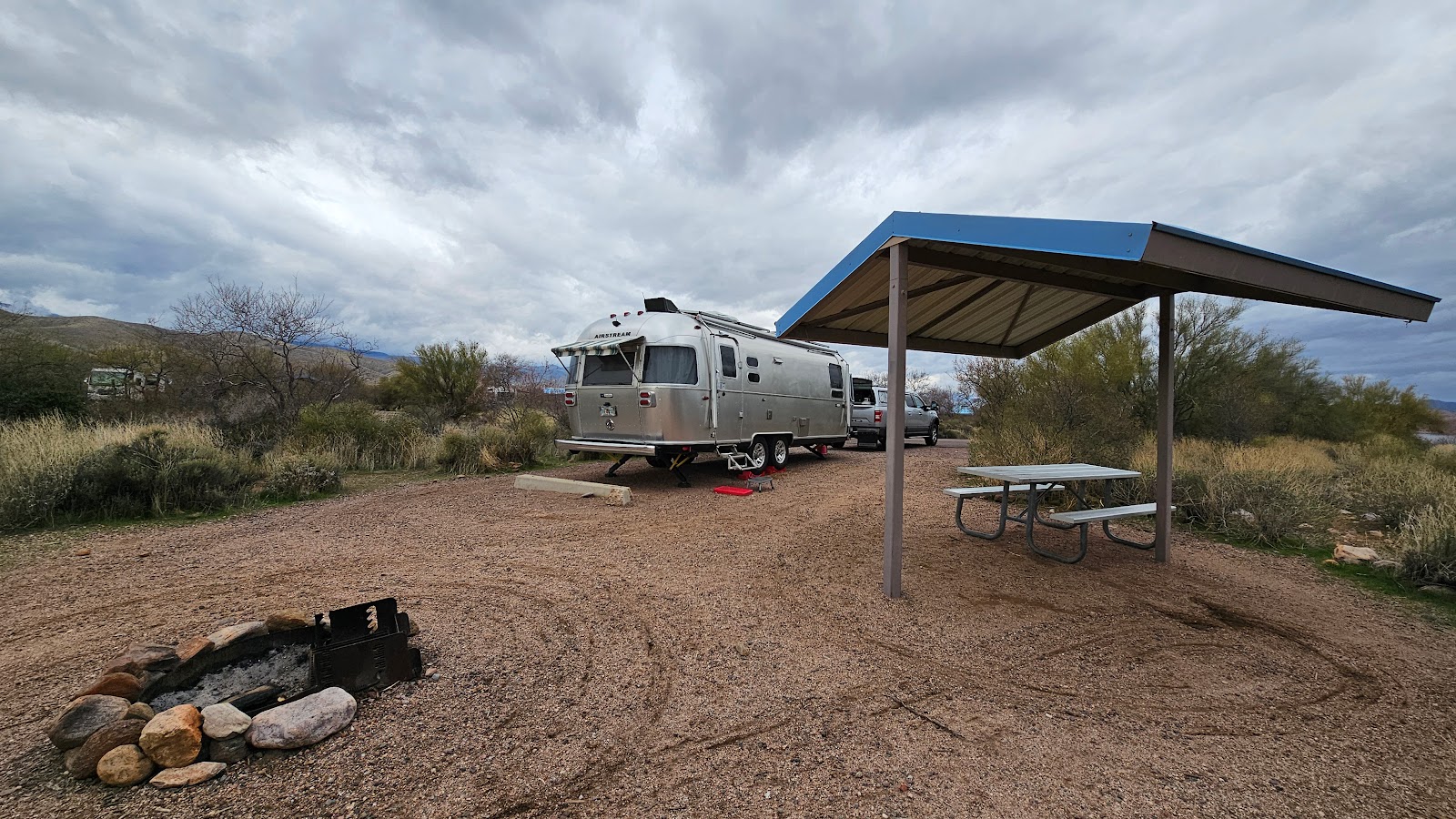
Just 5-miles on the other side of the bridge we arrived at the Cholla Campground which is managed by the Tonto National Forest office.
Our site here for the next four nights does not have water or electric hookups, neither does our next two locations, which means we are going to be relying heavily on our propane furnance to keep us warm for the next 24 days and nights.
Now, who was the "genius" that planned to be unplugged for the coldest month of the year in Arizona?
Oh yeah, that would be me! At least the forecast is for temps in the low 40°Fs most of that time.


One is a hike and the other a scenic drive, we're going to get the hike done first while the tempuratures are still comfy.
The Tonto National Monument has two separate cliff dwellings that are open to the public for viewing.
The Lower Cliff Dwelling is a ½-mile self guided hike up a steep trail with 500' of elevation change. It's the one we did because the other option is to take a 1½-mile Ranger guided hike to the Upper Cliff Dwelling with 600' of elevation change. Yes, it's a longer hike, but it's much less steep than the one we did.
We actually didn't have a choice of which hike to take because the Upper Cliff Dwelling hike is by reservation only. The reservations open in October for the entire November to April season and typically are sold out before the season begins.
Guess I didn't research this visit enough to come across that little tidbit of information. I usually only research an activity to the point of deciding whether or not it's something that might interest us. Once it's added to the list of things to do I stop researching because I don't want to feel like we've already been there before we even arrive.
TONTO NATIONAL MONUMENT

|
||||||||
 Even from the Visitor Center parking lot there's quite a nice view of the lake.
|
||||||||
 Also evident from the parking lot is how steep the terrain is here.
|
||||||||
 A closeup of the crown of one of the abundant saguaro cactuses found here.
|
||||||||
 Still in the parking lot we can see the Lower Cliff Dwelling high up above us.
|
||||||||
 Here is a little bit closer view of our destination.
|
||||||||
 Looking over our shoulders halfway up the trail the view was just stunning.
|
||||||||

|
||||||||
 The higher we go the better the view.
|
||||||||

|
||||||||

|
||||||||
 Finally getting close! See the Ranger at the top waiting for us to arrive?
|
||||||||
 How about now?
|
||||||||
 Before starting to explore the cliff dwelling we took a moment to enjoy the view.
|
||||||||
 The three storied structure was tucked up under a protective overhang.
|
||||||||
 Some of the wooden floor joists were still intact.
|
||||||||
 The dwelling was three rooms deep under the overhang.
|
||||||||
 Some of the rooms appeared to be darkened with soot from fires.
|
||||||||
 How about a 1000 year old mortar and pestle?
|
||||||||
 This room could have served as an indoor kitchen.
|
||||||||
 Time to head back down and leave the Ranger to talk with others that are almost here.
|
||||||||
 This is a photo of the photo on the Visitor Center wall showing the Upper Cliff Dwelling.
It's much larger and twice as many rooms as the one we visited today, maybe next time!
|
|

After we finished exploring the Lower Cliff Dwelling at the Tonto National Monument we headed for the upper entrance of the Apache Trail.
The Apache Trail is centuries old trail which at first was nothing more than a trail used by the original inhabitants of this area some 1500 years ago. Today it is a dirt road than travels from the Theodore Roosevelt Dam down to the town of Apache Junction. It roughly follows the path of the Salt River after it passes through the dam.
Only the first and last few miles of the trail are paved, but the rest of the 44-miles are a fairly well maintained dirt road.
In 2019 there was a hugh wildfire (The Woodbury Fire) that burned 123,000+ acres near the trail. Then later the same year there was a huge rain event the washed out and buried a 7-mile section of the trail. To date (JAN 2024), less than 2-miles of the trail has been reopened to vehicular traffic.
We drove the upper 13-miles of the trail down to the Apache Lake Marina & Resort where we thought we would enjoy a lunch in their restaurant.
When we arrived we found the convenience store, restaurant and bar all closed. At least the bathrooms were open! There was a sign on the door stating they were closed from November 30th until February 29th. It would have been nice if they mentioned that somewhere on their website, they didn't, because I looked when I got back to THE POD.
Anyway, we enjoyed the scenic drive and found a few backcountry campsites that would work out well if we ever find ourselves in a Class B van.
Here are some photos of our trip!
THE APACHE TRAIL (AZ-88)
|
||||||||
 At the top of the trail is the Inspiration Point Overlook,
where you can see the Theodore Roosevelt Bridge on one side...
|
||||||||
 ...and the backside of the Roosevelt Dam on the other.
|
||||||||
 I hope that rock wall is done shifting or there's going to be a big problem.
|
||||||||
 Here's a view from the other side of the dam.
|
||||||||
 Now we begin the dirt road section of the Apache Trail as we say goodbye to the asphalt.
|
||||||||
 Here the road hugs the shoreline of the Salt River.
|
||||||||
 Just beautiful, don't you think?
|
||||||||

|
||||||||
 Now we're at the Apache Lake Marina and basically the end of the road for the upper section.
|
||||||||
 There is plenty more road lower than here but it's all closed down to Tortilla Flats.
|
||||||||
 That's part of the Apache Lake Marina down in the lower right corner of the photo.
|
||||||||
 This is part of the Burnt Coral Campground's parking for boat trailers.
|
||||||||
 Here are a few of the campsites along the shoreline.
|
||||||||
 How many arms can you count on that Saguaro Cactus in the center of the photo?
|
||||||||
 A view from one of the campsites in the Upper Burnt Coral campground.
|
||||||||
 We're back on pavement after two hours of dirt road driving, aaaaaah!
|
|

Would you like to be notified of new blog posts?

