Want to see our Visited States Data, our State by State Bucket Lists or our Visited Parks and Campground lists?

Then click on the image above to go to our other website.

GRAPEVINE HILLS CAMPSITE #1 - BBNP (TX)


MONDAY - We have a very short 34-mile travel day today.

We'll be leaving the Cottonwood Campground (elev. 2134') and heading towards our Grapevine Hills Campsite (elev. 3930') which should give us a little relief from the 90°F temperatures we've recorded the last couple of days.

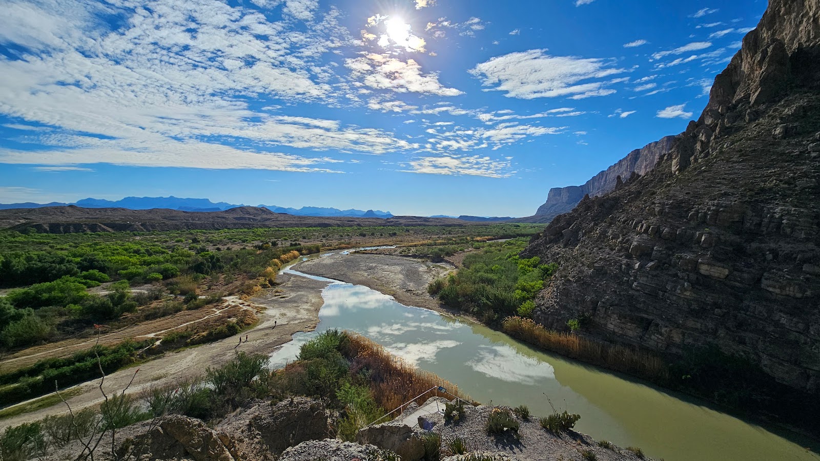
Cottonwood Campground was down low along the Rio Grande River and tucked into a protected valley with lots of trees and river reeds to shield us from the high winds. During our 4-day visit the highest wind recorded at our campsite was 31MPH.

Now we're here at Grapevine Hills and while we enjoy the lower temperatures we've lost our protection from the winds. The moment I set up our anemometer (wind measurement device) it instantly recorded a 34MPH gust. The big difference here is we are constantly under a 20-25MPH breeze which makes it difficult to leave any windows open.


At the base of the Chisos Mountains are two peaks which are called "Mule Ears" (elev. 3881').

We continued along our drive and eventually started gaining elevation. Near the top of the route is a side road to a pullout called Sotol Vista, which we took the time to check out.

I waited in the truck while Tricia took the photos, we were double parked.

That's the road we traveled UP to get here from Cottonwood Campground.


It wasn't long before we were pulling into our campsite here at Grapevine Hills. Our site, GH1 is less than 500-yards off the main highway that travels through the park. It is separated from the highway by a tall natural berm, so we can't see, or be seen, from the highway.

Grapevine Hills #1 is rated for an occupancy of as many as 3 RVs.

The road goes to the very popular Balanced Rock Trailhead 6-miles down the road.
There are also four more campsites along the road, so yeah, a lot of traffic goes by each day.

Luckily we are just below the road level and the wind blows the dust away from our campsite.

The anemometer and Starlink are both up and running flawlessly, no obstructions.


TUESDAY - Today we've decided to drive up into the Chisos Mountains and have lunch at the Chisos Mountain Lodge's dining room.

Chisos Mountains Lodge is only 6.5-miles from the main highway, but over that short distance you'll gain 1419' in elevation. So yes, when I say we drove UP into the mountains I mean UP!

Seen in the center is Casa Grande (elev. 7325). The lodge sits at the base of the mountain.

One of the five tight blind 180° turns in the road leading up to the lodge and campground.

The Chisos Basin Campground (elev. 5401) has a trailer limit of 20' and RV limit of 24'.


Their dining room is open to the public (meaning it's not just for lodge guests) for breakfast, lunch and dinner. Tricia ordered the Chicken Wrap and I had the Cheeseburger with fries.

After lunch we took the time to hike the short .03-mile Window View Trail. It's easy to see why they call it "The Window" as you can see all the way to Mexico from up here.


When we arrived back at the trailhead located behind the Camp Store and Visitor Center I got the strange feeling that we were being watched!

Sure enough, a few seconds later two young bucks popped up out of the brush. Just a few more seconds passed when two more, even younger bucks, came walking out of the tree line to our left.

Four young bucks all sighted in the same location, we hardly ever see even one. Judging by their behavior I'm going to say it happens a lot here at this location.

Yeah! That was me they cautiously passed by on the sidewalk.


WEDNESDAY - Big Bend National Park is large at just over 800,000 acres. It offers many different kinds of camping opportunities.

Most everyone is familiar with the three no-hookups campgrounds operated by the National Park Service, Cottonwood, Rio Grande Village and Chisos Basin. There is also the privately managed Chisos Mountains Lodge (with hotel style rooms) and the Rio Grande Village RV Park (with water/electric/sewer hookups).

What most people may not be aware of, or possibly just not interested in, are the 23 Primitive Roadside Campsites that can be reserved in advance at Recreation.gov for a reasonable fee.

If you want an even more remote and primitive camping experience there are another 41 Backcountry Sites that require you to reserve in person the day before, or the day of, the dates you desire to camp at the Visitor Centers. Of course these sites are only accessible with a high-clearance 4-wheel vehicle.

In other words, there's a little something for everbody here at Big Bend National Park.

Early morning at "The Window" from the Chisos Mountains Lodge.


Would you like to be notified of new blog posts?


COTTONWOOD CAMPGROUND - BBNP (TX)


THURSDAY - We have only a short 66-mile commute today between campsites, but the scenery was spectacular.

The following two photos were taken while we were still inside of Big Bend Ranch State Park and heading towards Big Bend National Park next door.


In February, two years ago, we spent two weeks in Big Bend National Park with 6-nights spent at Rio Grande Village Campground on the east side of the park followed by 8-nights at Cottonwood Campground on the west side of the park.

This time we're entering the park from the west side, so our first 4-nights will be at Cottonwood Campground where we intend to repeat the Santa Elena Canyon hike we did last time.

Just like two years ago they were pumping water out of the nearby Rio Grande River
and irrigating the grassy area behind the campsites.

This time we're in Campsite #5, two years ago we were two sites away in Campsite #9.


SATURDAY - We didn't get as early of a start as we planned, but we did get out and hike the 1.6-mile Santa Elena Canyon Trail this morning.

The outside temperatures were 48°F when we woke this morning at 7:30AM, but had only risen to 51°F by 8:30AM when we originally planned to leave.

By 9:00AM it was 55°F and we headed out, because later this afternoon the temperatures are forecast to be approaching 90°F. Welcome to the desert!


The Santa Elena Canyon Trailhead is only 8-miles west of the Cottonwood Campground. Along the road we passed this burro just munching away on the grasses at the very edge of the road. We looked deeper into the brush and saw two more doing the same thing.

About 1-mile before you reach the trailhead at the end of the road there is a pullout where you get this excellent view of the Santa Elena Canyon entrance.


When we arrived at the trailhead there were already about a dozen other cars and trucks in the parking lot. That meant we would be crossing paths with people coming out as we are still heading in. There are a few blind corners where there isn't room to safely pass someone, but you can usually hear them coming from a distance.

Especially if someone is yelling out ECHO or WOO HOO around the corner, and that's the adults, the children are usually a little more difficult to entertain.


SANTA ELENA CANYON TRAIL
BIG BEND NATONAL PARK (MARCH 2024)


SLIDE NUMBER
1OF32

It was 9:45AM and 60°F when we finally started down the trail.
SLIDE NUMBER
2OF32

Right away I was out in front while Tricia stopped to take some photos.
SLIDE NUMBER
3OF32

50-yards up the dry creek bed is where the trail starts to get challenging.
SLIDE NUMBER
4OF32

Then you backtrack the same 50-yards up on the cliff face.
SLIDE NUMBER
5OF32

That's where we encounter a very friendly roadrunner on the trail.
SLIDE NUMBER
6OF32

Turns out there was a pair of them leading us down the trail.
SLIDE NUMBER
7OF32

There's no zoom on this photo, it's taken from less than 2-feet away.
SLIDE NUMBER
8OF32

Now starts the FUN part, nowhere to go but UP!
SLIDE NUMBER
9OF32

Out in the full sun the ocotillo are in full bloom.
SLIDE NUMBER
10OF32

When entering the canyon the breeze picks up a little bit.
SLIDE NUMBER
11OF32

Those crumbled rocky areas on the right is where we saw dozens of mountain goats
two years ago, but we didn't see any this time around.
SLIDE NUMBER
12OF32

The bright red blooms against the deep blue sky was amazing.
SLIDE NUMBER
13OF32

Still gaining altitude but I think I see the top of the trail just up ahead.
SLIDE NUMBER
14OF32

Zoomed in at 10X we can see some cows on the Mexican side of the Rio Grande River.
SLIDE NUMBER
15OF32

More ocotillo blooms, it's why we're here a month later this time around.
SLIDE NUMBER
16OF32

SLIDE NUMBER
17OF32

I'm way out in front now, Tricia must be taking A LOT of photos.
SLIDE NUMBER
18OF32

I found a good place to wait. It's where the trail starts being shaded by the canyon walls.
SLIDE NUMBER
19OF32

Everything from here forward will be in the shade.
SLIDE NUMBER
20OF32

In the shade the ocotillo haven't bloomed yet.
SLIDE NUMBER
21OF32

Back down closer to the river we start seeing more foilage along the trail.
SLIDE NUMBER
22OF32

Lots of reeds and bamboo are found on the river banks.
SLIDE NUMBER
23OF32

Mexico on the left and the United States on the right.
SLIDE NUMBER
24OF32

The end of the trail, unless you're prepared to go swimming.
SLIDE NUMBER
25OF32

We spent about ten minutes enjoying the end of the trail before heading back.
SLIDE NUMBER
26OF32

As we turn to head back the trail starts heading up.
SLIDE NUMBER
27OF32

It doesn't look that far, but we're still a half mile from the start.
SLIDE NUMBER
28OF32

Doesn't look like the cows have moved an inch.
SLIDE NUMBER
29OF32

Some people just come look at the water and leave, they don't know what they're missing.
SLIDE NUMBER
30OF32

It's a lot easier going down than coming up.
SLIDE NUMBER
31OF32

This concludes our hike of Santa Elena Canyon.
SLIDE NUMBER
32OF32

Looks like the cows are getting ready to move on also.


For some reason I don't remember the trail being as difficult two years ago. I know it's the same trail! Maybe it's the fact I'm two years older, 15-lbs. heavier and the temperature is 10°F warmer this time around. It was 80°F when we returned to ROVER at 11:45AM, a full two hours after we started. By dinnertime, it would be in the low 90°Fs!


Now that the hiking is complete, it's time to go check out the little store at the Castalon Visitor Center just a mile passed the campground.

If I'm remembering correctly from 2-years ago they sell ice cream there!


Would you like to be notified of new blog posts?