When we stopped last night in New Mexico we were only 22-miles short of the Arizona border.
Since the AAA (American Automobile Association) website informs me that the average price of a gallon of gas in Arizona is 28¢ higher than here in New Mexico, we are going to stop just 5-miles before the border and fill up our half empty tank with 18-20 gallons of gas before crossing into Arizona.
Just after crossing into Arizona we saw the prices jump 10-15¢ a gallon and then an hour later when we we 75-miles from the border we saw that 28-30¢ jump we were expecting. Glad we filled up when we did.
All day yesterday and today, over the course of more than 200-miles, we've been seeing billboards all along Interstate-10 advertising "The Thing?".
We know what it is because we looked it up last night, but I just can't resist not checking it out. Besides, it's lunchtime and there's a DQ Grill & Chill at the same Exit.
"The Thing?" turns out to be a supersized gift shop with a wide variety of souvenirs, plus a small museum filled will all kinds of odd displays. There's a $5 fee to enter the museum, so we passed up the opportunity to see exactly what's inside. I'm not that curious!
"The Thing?" Exit is literally in the middle of nowhere.
Oh yeah something else I should mention, the gasoline at "The Thing? Exit" is 40¢ a gallon more than the price at the next exit down the Interstate. Don't fall for that little trick!
That must be how they pay for the literal hundreds of billboards along the highway, in both east and west directions!
Another 4-miles west on the Interstate and we passed this mountain of boulders, where from the top of the pass we could see far off in the distance (20-miles) the town of Benson, AZ (pop. 5355), which just so happens to be our exit to the Kartchner Caverns State Park.
It was exactly 51 weeks ago we stayed here in this very same campground and we both did the 2 different cave tours they offer. Imagine our surprise when they informed us that "no photography" is permitted inside of the cave.
At the time we had done 57 other cave tours around the country and not one of them had banned photos.
When we mentioned that to the cave tour operator they casually mentioned that once a month, on the 3rd Saturday, they offer a "Special Photographers Tour" of the cave. Last year the 3rd Saturday of January was the week before we were here, darn it!
Tricia was very disappointed she couldn't take photos to share with you, so me being the nice guy that I am, immediately and secretively made sure our route would bring us back to Arizona in December and booked the photographers tour for her as a future Christmas present.
Then when we decided to spend an entire month visiting with Tricia's brother in Texas during the Christmas and New Year holidays I had to switch her reserved tour from December to January, thankfully they had an opening!
Tricia will be doing the Photo Tour on her own, mostly because I don't usually take any of the photos, but also because the "Photo Tour" costs five times as much as the "non-Photo" tours that are open to the general public.
I hope she enjoys it, and comes away some good photos to share with you all, because I've aleady seen the cave!
Our campsite has a pretty nice view out the back.
This is the very first time I've mounted the Starlink pole to the rear bumper, I like it!
FRIDAY - Tricia is going on a 3-mile hike this morning without me.
The trail goes up into that mountain behind our campsite that you can see in the previous photo. Most of the time she'll be within sight of the campground, but just in case she needs help finding her way back or suffers an injury, she'll be carrying her trusty Garmin In-Reach Mini and can send a text message to my phone and an email to my laptop for help.
She'll also be checking in with an "ALL OK" message every 30-minutes, complete with GPS coordinates, so I can track her progress along the trail on Google Maps using my laptop.
This will only be the second time she's used the Garmin to keep safe, the last time was back in August when we were at Theodore Roosevelt National Park in North Dakota.
FOOTHILLS LOOP TRAIL KARTCHNER CAVERNS STATE PARK
SLIDE NUMBER
1
OF
24
At 7:00AM sharp Tricia left THE POD and started her early morning hike.
SLIDE NUMBER
2
OF
24
A few minutes later the sun peeked above the horizon and gave everything a warm glow.
SLIDE NUMBER
3
OF
24
You have to be quick with your photos because this lighting only last a few minutes.
SLIDE NUMBER
4
OF
24
The lighting even made this prickly pear cactus look inviting to touch.
SLIDE NUMBER
5
OF
24
Walking around the backside of the mountain temporarily put Tricia back in the shadows.
SLIDE NUMBER
6
OF
24
The top of that mountain is the goal for today.
SLIDE NUMBER
7
OF
24
Not sure why, but I think this is my favorite photo for the day.
SLIDE NUMBER
8
OF
24
I like the way the stalk on the left started out growing at a 30° angle and then corrected itself and started reaching directly straight up.
SLIDE NUMBER
9
OF
24
Another of my favorites for the day.
SLIDE NUMBER
10
OF
24
A view of the mountains in Mexico, just 40-miles south of our location.
SLIDE NUMBER
11
OF
24
This ⅓-mile spur trail will take Tricia to the top of the mountain.
SLIDE NUMBER
12
OF
24
At the top you'll find the bench where Tricia ate her snack and took a rest.
SLIDE NUMBER
13
OF
24
Snacks over, time to grab the backpack and poles and begin the descent...
SLIDE NUMBER
14
OF
24
...but first, one last look at the 360° view.
SLIDE NUMBER
15
OF
24
This pyramid of rocks is obviously not a natural formation.
SLIDE NUMBER
16
OF
24
Tricia was not alone during her time on the mountain top.
SLIDE NUMBER
17
OF
24
It's all downhill from here.
SLIDE NUMBER
18
OF
24
Tricia's way of marking her photos to show she's back on the main trail.
SLIDE NUMBER
19
OF
24
One of the few places where there was evidence of manmade trail improvements.
SLIDE NUMBER
20
OF
24
At this point the trail passes under an elevated roadway that the tram uses to transport people from the Visitor Center to the entrance of the cave tour.
SLIDE NUMBER
21
OF
24
Once past the Visitor Center it's a short hike to the just outside of the campground.
SLIDE NUMBER
22
OF
24
Well maybe not that short, it's still a half mile to the campground.
SLIDE NUMBER
23
OF
24
I'm not sure what the purpose of these four metal posts along the trail is?
SLIDE NUMBER
24
OF
24
There's THE POD, hiding on the other side of those mesquite and cedar trees.
SATURDAY - Today's the big day, this afternoon at 4:30PM Tricia will begin her "Photo Tour" here at Kartchner Caverns.
She will have 2-hours inside the cave to take photos. There were 14 other photographers on the tour and nearly half were only taking cell phone pictures.
KARTCHNER CAVERNS
SLIDE NUMBER
1
OF
22
SLIDE NUMBER
2
OF
22
SLIDE NUMBER
3
OF
22
SLIDE NUMBER
4
OF
22
SLIDE NUMBER
5
OF
22
SLIDE NUMBER
6
OF
22
SLIDE NUMBER
7
OF
22
SLIDE NUMBER
8
OF
22
SLIDE NUMBER
9
OF
22
SLIDE NUMBER
10
OF
22
SLIDE NUMBER
11
OF
22
SLIDE NUMBER
12
OF
22
SLIDE NUMBER
13
OF
22
SLIDE NUMBER
14
OF
22
SLIDE NUMBER
15
OF
22
SLIDE NUMBER
16
OF
22
SLIDE NUMBER
17
OF
22
SLIDE NUMBER
18
OF
22
SLIDE NUMBER
19
OF
22
SLIDE NUMBER
20
OF
22
It's hard to believe that all the formations in this cave are created by single drops of water.
SLIDE NUMBER
21
OF
22
When soda straw formations become clogged they branch out in all different directions.


 At 7:00AM sharp Tricia left THE POD and started her early morning hike.
 A few minutes later the sun peeked above the horizon and gave everything a warm glow.
 You have to be quick with your photos because this lighting only last a few minutes.
 The lighting even made this prickly pear cactus look inviting to touch.
 Walking around the backside of the mountain temporarily put Tricia back in the shadows.
 The top of that mountain is the goal for today.
 Not sure why, but I think this is my favorite photo for the day.
 I like the way the stalk on the left started out growing at a 30° angle
 Another of my favorites for the day.
 A view of the mountains in Mexico, just 40-miles south of our location.
 This ⅓-mile spur trail will take Tricia to the top of the mountain.
 At the top you'll find the bench where Tricia ate her snack and took a rest.
 Snacks over, time to grab the backpack and poles and begin the descent...
 ...but first, one last look at the 360° view.
 This pyramid of rocks is obviously not a natural formation.
 Tricia was not alone during her time on the mountain top.
 It's all downhill from here.
 Tricia's way of marking her photos to show she's back on the main trail.
 One of the few places where there was evidence of manmade trail improvements.
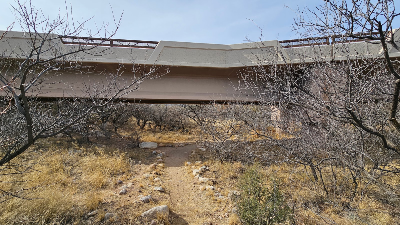 At this point the trail passes under an elevated roadway that the tram uses
 Once past the Visitor Center it's a short hike to the just outside of the campground.
 Well maybe not that short, it's still a half mile to the campground.
 I'm not sure what the purpose of these four metal posts along the trail is?
 There's THE POD, hiding on the other side of those mesquite and cedar trees.


 It's hard to believe that all the formations in this cave are created by single drops of water.
 When soda straw formations become clogged they branch out in all different directions.
 The tour is over! Time to exit the cave.

