


With a relatively short moving day of just 107-miles, we planned a sightseeing stop along the route. Usually it's difficult to stop anywhere with THE POD, but I checked Google Map's satellite view and saw they have dedicated RV parking at the location where we wanted to stop. So we're going to give it a try!

That's one of the ten border crossings we haven't done yet, so now we're down to just nine.
Wondering what was so important that we made a side trip to New Mexico to go see? It wasn't merely to collect another border crossing.
There are two things actually that brought us to New Mexico. The one we stopped during our route to see was our 48th visited National Monument.
AZTEC RUINS NATIONAL MONUMENT

|
||||||||
 After viewing the park's film we stepped out the back door to this!
|
||||||||
 Something new to us is the use of green colored stones, used just for decoration.
|
||||||||
 This "Great Kiva" has been reconstructed to look exactly like it did some 900-years ago.
|
||||||||
 The inside has been reconstructed also. The best thing is, you're allowed inside too.
|
||||||||
 The ceilings show how much time, materials and energy it took to construct.
|
||||||||
 These doors and windows allow observers to get a peek of the ceremonies going on inside.
|
||||||||
 It is believed these dirt floor pits were used to grow herbs year round.
|
||||||||
 The raised area in the back is where the "presenter" could conduct ceremonies from.
|
||||||||
 By leaving the plaster off a section of this post you can see how it is reinforced.
|
||||||||
 Today's wooden steps were built directly over the original stone steps to preserve them.
|
||||||||
 We're back outside now, ready to see the rest of the property.
|
||||||||
 Another large community kiva.
|
||||||||
 The "T" shaped doorways are mostly exterior doorways, while rectangular doors are interior.
|
||||||||
 I squeezed through one of these 4.5' doorways and then called it quits.
|
||||||||
 Here they used rounded stones, again just for decoration.
|
||||||||
 It's hard to tell, but this is a doorway in the corner of the room.
It's unknown why they did this because it severely reduces the strength of the wall.
|
||||||||
 You caught me! But in my defense it is over 90°F today and there is zero shade.
|
||||||||
 Yet another large kiva, conveying there must have been a large population here.
|
||||||||

|
||||||||
 Here's another one of those "T" shaped exterior doors, but missing the header.
|
||||||||
 This area had a full second story, which obviously took a toll on the lower walls.
|
||||||||
 The "trail" took us through four interior rooms that led to the outside of the building.
The ceilings inside these room is all 900-year old construction.
|
||||||||
 Lots of decoration on this wall, two differnet color "stripes" and a layer of thin stones.
|
||||||||
 The "trail" led up to a roof where we got a birdseye view of the "Great Kiva".
|
||||||||
 Aztec Ruins National Monument was definitely worth the stop, even with THE POD.

There are many theories by scientists and archaeologists as to why so many of the Puebloan ruins were all abandoned in a short period of time in the late 1200s, no one knows for sure.
There are two words in that last sentence that the decendants of the Puebloan people have issue with today. Can you guess which two they are?
Ruins and abandoned! Their position is first, they are not abandoned! The inhabitants simply moved on to further the journey they have been on for their entire life. Secondly, they are not ruins. They believe their ancestors are still present in the village. So much so that when they visit, they ask permission to enter, just as it has always been.
A common saying is that everyone is welcome to visit, as long as they do it with respect!
There are two routes to get from the town of Aztec, NM (where the National Monument is) and the town of Navajo Dam, NM (where Navajo Lake State Park is) where our campsite awaits us.

There are no towns, no stop lights, not even a stop sign along the entire 26-mile distance. Take the other road choice and you'll pass through the towns of Bloomfield, Augustura, Blanco and Turley and I'm positive that one, if not all of them, will have a stop light or two. At the very least they'll have a reduced speed limit as you pass through town.
You're probably wondering why am I telling you this? The whole time we traveled on NM Highway 173, all 26-miles of it, we passed about 30 vehicles going in the opposite direction. Tricia will back me up on this, 28 of those 30 vehicles had one thing in common. No they weren't all built by the same manufacturer, there were Chevys, Fords, GMCs, Rams and even a couple of Toyotas.
What each and every one of them had in common is they were all "white" pickup trucks. They didn't all have the same company logo on the side, or even logos at all, just the fact that every one of them was a "white" pickup truck.
I found that very odd and almost comical that every time we saw another vehicle coming toward us on the road it was another "white" pickup truck.
We eventually made it to our campsite, and what a nice campsite it is! After 7-years I'm getting real good at picking great campsites from just looking at a black and white map on somebody's poorly designed reservation site.


Also with the visit to Aztec Ruins NM going so well, even with THE POD in tow, we are going to try it again tomorrow when we leave here and visit Chimney Rock NM up in Colorado. That's right, we're headed back to Colorado after just two nights in New Mexico.
One thing we like to do when at a campground is drive around the rest of the campsites to see if there would have been a better choice for us. That's going to be a little bit difficult here at Navajo Lake State Park with it's seven campgrounds spread out over twenty miles along Navajo Lake and the San Juan River.
We're going to be able to check out all but two of them today and still be back at THE POD in time for lunch.
NAVAJO LAKE STATE PARK AND NAVAJO DAM

|
||||||||
 There wouldn't even be a Navajo Lake if it weren't for the Navajo Dam (completed in 1963).
|
||||||||
 The Navajo Dam is an earthen dam, 402' high, 3,648' long and 2,566' wide at the bottom.
|
||||||||
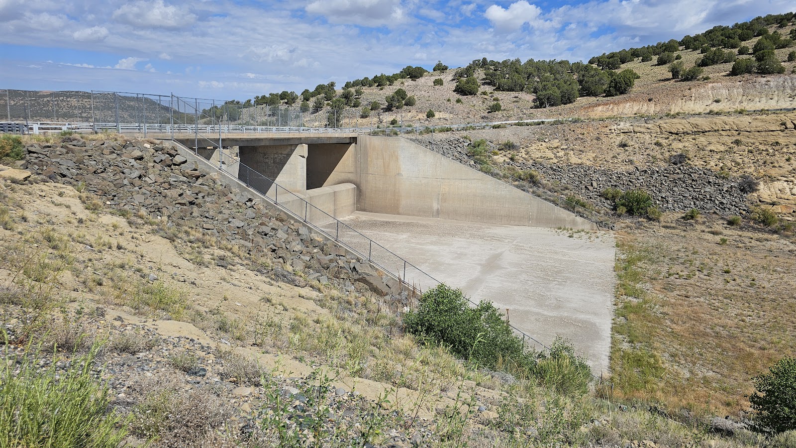
 This is the bottom of the spillway in case the lake ever overflows the dam.
|
||||||||
 This is the top of the spillway on the lake side. Notice the additional 20' tall wall.
|
||||||||
 This is the top of the 138' wide spillway on the river side of the dam.
|
||||||||
 Here you can see the entire 410' long spillway chute.
|
||||||||
 The crest of the dam is just 30' wide, enough for a 2-lane road and narrow shoulders.
|
||||||||
 All together it makes for a pretty sizable construction site.
FYI - The spillway has only been used once in 1973 when the lake was first filled to capacity.
After checking out four other campgrounds here in Navajo Lake State Park we've come to the conclusion that we are in the right campground. The only other campground we would consider visiting with THE POD is the Cottonwood Campground, which is 10-miles down river from the dam.


How about our State by State Bucket Lists or Visited Campgrounds List?
If so, click on the sign below to be taken to our other website.

Would you like to be notified of new blog posts?

