TUESDAY - This morning we broke camp and were well on our way to our next destination by 8:00AM.
As I mentioned we have a very special travel day in store for us. In case you haven't already figured it out, we will be traveling through Monument Valley on our way to our next campsite on the other side.
FYI - I've probably already uploaded a new Facebook Group Cover Photo by now.
I told Tricia not to worry if she doesn't get every single photo she wants today because sometime over the next five days we will revisit this portion of the route without THE POD in tow.
As soon as we reached the town of Kayenta we turned off of US-160 and onto US-163. The scenery immediately began to change for the better.
This solar farm is just outside of town, along with Agathla Peak, an impressive rock formation.
Just across the street is a formation called Observer Rock.
I don't know about Tricia, but I was getting pretty excited about what was coming next and we haven't even made it into Utah yet.
Just 30-minutes later in Utah we were beginning to see the back side of some pretty iconic formations. I'm not even going to pretend to know the names of these formations, so just enjoy the photos.
This is quickly getting out of hand! I better start a slideshow for the rest of the photos and remember, this is just our first of possibly three times visiting these locations.
MONUMENT VALLEY (IN UTAH)
SLIDE NUMBER
1
OF
22
Once we go around this curve in the road everything changes!
SLIDE NUMBER
2
OF
22
We get our first look at the "front" of the iconic monuments.
SLIDE NUMBER
3
OF
22
Front is relative I guess. It's just the side you always see in the movies and in photos.
SLIDE NUMBER
4
OF
22
Now there's a shot worth taking!
SLIDE NUMBER
5
OF
22
Down at the bottom of this hill it is utter chaos.
SLIDE NUMBER
6
OF
22
That's Forrest Gump Point down there and no way was I stopping with THE POD.
SLIDE NUMBER
7
OF
22
A short time later we were entering the town of Mexican Hat, UT.
SLIDE NUMBER
8
OF
22
It can be found on the shores of the muddy San Juan River.
SLIDE NUMBER
9
OF
22
This rock formation is how the town gots it's name.
SLIDE NUMBER
10
OF
22
This is the beginning of the 3.5-mile long entrance drive to our campground.
SLIDE NUMBER
11
OF
22
That's the "Day Use Area" of Goosenecks State Park.
SLIDE NUMBER
12
OF
22
To the left of the Entrance Gate you can camp anywhere there is room.
SLIDE NUMBER
13
OF
22
We may have used up some of those Good Karma Points today because as we were arriving another Airstreamer was vacating what I consider to be the best spot in the park.
SLIDE NUMBER
14
OF
22
Our view out the back is of the San Juan River over 1100' below the rim we're on.
SLIDE NUMBER
15
OF
22
We have not one, but two, Horseshoe Bends in the river behind our site.
SLIDE NUMBER
16
OF
22
Someone previously made a heck of a nice rock fire pit, but we won't be using it.
SLIDE NUMBER
17
OF
22
We had to put two new "C" batteries in the anemometer today...
SLIDE NUMBER
18
OF
22
...just to find out what I already knew. These 35+MPH wind gusts are just about strong enough to blow us over the edge.
SLIDE NUMBER
19
OF
22
Don't worry! We've got the wheels blocked from rolling.
SLIDE NUMBER
20
OF
22
Look, there's someone out rafting on the river today.
SLIDE NUMBER
21
OF
22
I wonder if the same person who built the firepit made this labyrinth.
SLIDE NUMBER
22
OF
22
This formation is located on the far side of the canyon.
At just 10-acres in size, Goosenecks State Park is one of Utah's smallest state parks, but what it lacks in size it more than makes up for with outstanding scenery.
The unique "goosenecks" in the San Juan River below are known as an "entrenched meander". It takes 12-miles to kayak through the area, but it's only 5-miles "as the crow flies".
The park is open year round and offers First-Come-First-Serve camping at $10 a night. There's no electric, no water and no dump station, but there are vault toilets. As a bonus, on a clear night, you have an unobstucted view of the Milky Way.
WEDNESDAY - Now that we are in a location where Tricia has reliable cell phone signal, she and her girlfriend back in Florida have resumed their early morning "Walk and Talk".
Even before the sun is over the horizon Tricia is out there "pounding the pavement" so to speak. Today it was more like "pounding rocks" down the additional mile of roadway between THE POD and the end of the road.
Even before sunrise THE POD and ROVER seem to outshine all the other RVs in the park.
See that tall cliff that goes out to the left and ends in a point? That's where we're headed today.
Today's sightseeing is going to be an adventure. Much like the Shafer Trail that we drove when visiting Dead Horse Point State Park two years ago, today it's going to be the Moki Dugway.
The Moki Dugway, located inside of the Bears Ears National Monument, is a series of switchbacks along a gravel road that ascends 1200' over the course of just 3-miles with up to 10% grades.
Originally constructed in the 1950s by the Texas Zinc Mining Company, the Dugway was used to transport uranium ore from the Fry Canyon Mines over to a processing mill near Mexican Hat.
On a clear day (today is not) at the top you can see the "Valley of the Gods" here in Utah, the "Sleeping Ute Mountain" over in Colorado, and "Shiprock" down in New Mexico.
Another interesting nearby destination is up on the Cedar Mesa at Muley Point (6297' of elevation), where we will get an even higher view of the San Juan River.
THE MOKI DUGWAY AND MULEY POINT
SLIDE NUMBER
1
OF
34
While it was raining cats and dogs to the south of us, we weren't getting a single drop.
SLIDE NUMBER
2
OF
34
I know the Moki Dugway is up ahead of us, but how are we going to get up that mountain?
SLIDE NUMBER
3
OF
34
Valley of the Gods to the right and the Moki Dugway straight ahead.
SLIDE NUMBER
4
OF
34
Luckily ROVER, even when fully loaded with two passengers, is still under 8000 lb.
SLIDE NUMBER
5
OF
34
After the very first switchback the pavement ends and the gravel roadway begins.
SLIDE NUMBER
6
OF
34
That first long climb doesn't look too steep for ROVER to handle.
SLIDE NUMBER
7
OF
34
This section of the road is plenty wide for two large vehicles to pass each other.
SLIDE NUMBER
8
OF
34
We are about halfway to the top now.
SLIDE NUMBER
9
OF
34
That's a long way back down to the bottom.
SLIDE NUMBER
10
OF
34
Just around this corner and we'll be on top of Cedar Mesa and the Moki Dugway.
SLIDE NUMBER
11
OF
34
Now we just have 5-miles of this bumpy dirt road to get to Muley Point.
SLIDE NUMBER
12
OF
34
From Muley Point you can see the formations in Monument Valley off in the distance.
SLIDE NUMBER
13
OF
34
This is about 10-miles downstream from our campsite view.
SLIDE NUMBER
14
OF
34
YEP, that's the same muddy water of the San Juan River down there.
SLIDE NUMBER
15
OF
34
Some people may be brave enough to walk out onto that flat rock, NOT ME!
SLIDE NUMBER
16
OF
34
Can you spot the 4 RVs on the opposite rim of the canyon wall?
SLIDE NUMBER
17
OF
34
They are still there alright, we saw them on the way in.
SLIDE NUMBER
18
OF
34
We stopped to talk with them on the way out and Tricia texted them her photos.
SLIDE NUMBER
19
OF
34
A final few shots before we start heading back down to the campground.
SLIDE NUMBER
20
OF
34
SLIDE NUMBER
21
OF
34
SLIDE NUMBER
22
OF
34
SLIDE NUMBER
23
OF
34
OK, five more miles back down the same dirt road.
SLIDE NUMBER
24
OF
34
That first curve looks a lot scarier from this angle.
SLIDE NUMBER
25
OF
34
FYI - There are no guardrails on the Moki Dugway.
SLIDE NUMBER
26
OF
34
Tricia thought this rock looked like a gorilla face, I have to agree.
SLIDE NUMBER
27
OF
34
This is the narrowest spot of the Dugway. To the left of that barrel is an immediate 500' plunge to the bottom of the Dugway.
SLIDE NUMBER
28
OF
34
YEAH, pavement, we're almost to the bottom now.
SLIDE NUMBER
29
OF
34
One more obstacle to avoid, don't those huge rocks look ready to tumble down onto the road?
SLIDE NUMBER
30
OF
34
This cliff face to the east is just stunning.
SLIDE NUMBER
31
OF
34
Mother Nature has been hard at work carving this spectacle for us to admire.
SLIDE NUMBER
32
OF
34
This is the view from the Day Use Area of the park.
SLIDE NUMBER
33
OF
34
THE POD looks awful lonely sitting over there all by itself.
SLIDE NUMBER
34
OF
34
That's a pretty wondelful backdrop to photograph with THE POD.
THURSDAY - Tricia was once again up before dawn and out walking around the park.
She snapped these two photos that show how we have our own little "campsite thumb" that sticks out over the canyon.
Today's sightseeing activity is driving the scenic 16.3-mile "Valley of the Gods" road.
You can think of it as a "mini" Monument Valley without all the crowds.
The west entrance to Valley of the Gods is at the base of the Moki Dugway and just 6-miles down the road from the Goosenecks State Park entrance. Just like the Moki Dugway, Valley of the Gods is located entirely within the enormous Bears Ears National Monument.
I researched online to find out if it was better to travel the Valley of the Gods road from "east to west" or "west to east" and couldn't find a definitive answer. So I decided we'd travel west to east first and then make a u-turn and do it all over again.
About 3-miles into the drive we both looked at each other and said, "no way were we going to travel this road twice in one day". To say the road is rough is putting in mildly, we were hard pressed to get ROVER over 20MPH without rattling our brains. With deep dry washes to traverse and miles of washboard ruts to contend with we were happy we did it, but don't want to do it again.
Many of the rock formations have been named. With names like Lady in the Bathtub, Castle Butte, Battleship Rock, Franklin Butte, Rooster Butte, Setting Hen Butte and Seven Sailors Butte, it was hard to figure out which butte is which. Other than Lady in the Bathtub, we couldn't figure out the rest. There is no signage what so ever along the road to tell you what you're looking at.
I'm sure we got a photo of each one and I've named them in the order in which they appear on the route, so maybe you all could help name them in the comments?
VALLEY OF THE GODS
SLIDE NUMBER
1
OF
34
I'm pretty sure I can name this one.
SLIDE NUMBER
2
OF
34
It sure looks like a "Lady in the Bathtub" to me.
SLIDE NUMBER
3
OF
34
I'm guessing "Castle Butte"? I don't know, what do you think?
SLIDE NUMBER
4
OF
34
Could this be "Battleship Rock"?
SLIDE NUMBER
5
OF
34
SLIDE NUMBER
6
OF
34
SLIDE NUMBER
7
OF
34
SLIDE NUMBER
8
OF
34
SLIDE NUMBER
9
OF
34
SLIDE NUMBER
10
OF
34
SLIDE NUMBER
11
OF
34
This is one of the "easy" gullies to cross. I wish we had photos of the "tough" ones.
SLIDE NUMBER
12
OF
34
SLIDE NUMBER
13
OF
34
SLIDE NUMBER
14
OF
34
SLIDE NUMBER
15
OF
34
SLIDE NUMBER
16
OF
34
SLIDE NUMBER
17
OF
34
Could that be "Sitting Hen Butte" off in the distance?
SLIDE NUMBER
18
OF
34
SLIDE NUMBER
19
OF
34
SLIDE NUMBER
20
OF
34
SLIDE NUMBER
21
OF
34
Up close it looks a little more like a "Sitting Hen" doesn't it?
SLIDE NUMBER
22
OF
34
SLIDE NUMBER
23
OF
34
I'm not sure who all these people were camping in tents...
SLIDE NUMBER
24
OF
34
...but this is BLM land so anyone can camp anywhere out here.
SLIDE NUMBER
25
OF
34
It's just gorgeous out here in Valley of the Gods.
SLIDE NUMBER
26
OF
34
It's still pouring rain over on Monument Valley.
SLIDE NUMBER
27
OF
34
SLIDE NUMBER
28
OF
34
SLIDE NUMBER
29
OF
34
SLIDE NUMBER
30
OF
34
SLIDE NUMBER
31
OF
34
SLIDE NUMBER
32
OF
34
SLIDE NUMBER
33
OF
34
SLIDE NUMBER
34
OF
34
And finally I think this one could be "Seven Sailors Butte"?
Shortly after we got back to the campground we had a rather large flotilla of rafters heading down river. It was quite a mixture too with large rafts, smaller rafts and even a few kayakers. I guess you go with whatever you're comfortable with.
FRIDAY - For today we thought we would just hang around the campsite and enjoy a quiet and uneventful day.
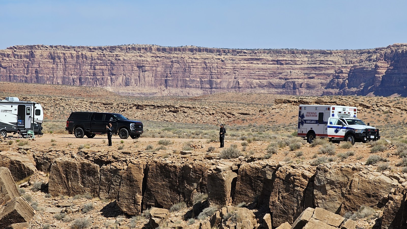
That was until around 10:30AM when an ambulance pulled into the campground and stopped just in front of our campsite. Two people exited the ambulance and immediately took out a pair of binoculars and began scaning the river banks below our campsite.
We saw a yellow raft tied up to the shoreline down at the bend in the river. That's nothing new, we've seen that before. It seems that's a popular rest stop along the route.
Then we heard a loud whirling sound from down in the canyon and sure enough a few seconds later a helicopter came into view down by the beached raft.
It took the pilot a few minutes to figure out how and where he was going to land, but eventually he made a decision and effected a perfect landing in some difficult circumstances.
The helicopter was on the ground for about 30-minutes and then we heard the engine start up again and soon they were off into the wild blue yonder. No sooner than the helicopter left then the ambulance was exiting the campground too.
I'm glad that whatever happened down there happened in the morning when the winds were calm. As I write this at 2:00PM the winds are gusting at 30+MPH and landing a helicopter down there may have not been an option.
Sometime around 1:00PM we saw the raft floating down the river with only one person onboard. I hope it turns out everyone is OK!
SATURDAY - When people mention Monument Valley in conversation most everyone pictures the 20-mile stretch of US-163 between the AZ/UT border and the town of Mexican Hat, UT.
Hollywood blockbusters such as Easy Rider (1969), directed by and co-starring Dennis Hopper; The Eiger Sanction (1975), directed by and starring Clint Eastwood and who could forget the scene in Forrest Gump (1994) when Forrest (starring Tom Hanks) ends his coast to coast to coast run across America.
But there is so much more to Monument Valley! Just below the AZ/UT border in Arizona there is a 17-mile scenic loop drive inside the Navajo Nation Reservation.
It is far away from the busy pullouts along US-163 and the crowds of people. For the very reasonable fee of $8.00 each you can drive at your leisure through the monuments and spend several hours enjoying the peace away from the crowds.
As luck would have it, the scenic drive has been closed to the public since June 3rd, ironically the day we drove passed it with THE POD, thanks to the heavy rains they've experienced everyday for the last few days.
It's been enough rain to turn the 17-mile red clay roadway into a muddy mess. We're hoping the road reopens today or tomorrow so we can drive back down to Arizona and see for ourselves.
GOOD NEWS! The road reopened today and there's not a cloud in the sky! WE'RE OFF TO GO CHECK IT OUT!
But first, we're going to have to drive 25-miles south, back through Utah's Monument Valley to get to Arizona where the Scenic Loop Drive is located.
MONUMENT VALLEY IN UTAH (SOUTHBOUND)
SLIDE NUMBER
1
OF
6
I don't understand the need to stand in the middle of the road to take your photo.
SLIDE NUMBER
2
OF
6
It's hard to see, but those people are sitting down in the middle of the road.
SLIDE NUMBER
3
OF
6
It's not that busy of a road, but the speed limit is 45MPH.
SLIDE NUMBER
4
OF
6
The road curves around the monuments to the right...
SLIDE NUMBER
5
OF
6
...where this large butte with several spires standing on their own is found.
SLIDE NUMBER
6
OF
6
One day this spire will eventually crumble to the ground, but not today!
After our 25-mile drive we arrived at the entrance gate to Monument Valley on the Navajo Nation. We paid our $8.00 each to enter the property and received a map of the scenic drive.
The map proved fairly useful in identifying the different formations, but there were also plenty of informational signs along the roadway.
I wish we would have had either had a map or roadsigns during the Valley of the Gods Scenic Drive, but hey, there the price was FREE.
Before starting the drive make sure to visit the gift shop and restaurant, also visit the restrooms because there are only a few locations with port-a-potties scattered around the scenic drive.
17-MILE SCENIC LOOP DRIVE THROUGH MONUMENT VALLEY ON THE NAVAJO NATION RESERVATION IN ARIZONA
SLIDE NUMBER
1
OF
38
From the back patio of the restaurant you get a bird's eye view of the start of the Scenic Drive.
SLIDE NUMBER
2
OF
38
The first monument on the drive is one of the most famous, it's called the West Mitten Butte.
SLIDE NUMBER
3
OF
38
The second monument to come into view is the almost as famous East Mitten View.
SLIDE NUMBER
4
OF
38
Next door is the Merrick Butte, named after an early prospector in the Valley.
SLIDE NUMBER
5
OF
38
SLIDE NUMBER
6
OF
38
This is described as Elephant Butte, I don't see it, do you?
SLIDE NUMBER
7
OF
38
With all the rain they've had this is the worst we encounter on the whole drive.
SLIDE NUMBER
8
OF
38
This formation is unique in the Valley, it's called The Three Sisters.
SLIDE NUMBER
9
OF
38
SLIDE NUMBER
10
OF
38
At John Ford's Point (movie director) you could have your photo taken on horseback ($10).
SLIDE NUMBER
11
OF
38
Here comes one of the $85 a seat "open air" tours.
SLIDE NUMBER
12
OF
38
They don't look like they're having fun under those dust masks, plus it's 94°F today.
SLIDE NUMBER
13
OF
38
This one is called Camel Butte, again I don't see it.
SLIDE NUMBER
14
OF
38
That big raised area is called Rain God Mesa.
SLIDE NUMBER
15
OF
38
The back side of Rain God Mesa.
SLIDE NUMBER
16
OF
38
Still Rain God Mesa. What do you want me to say, it's huge!
SLIDE NUMBER
17
OF
38
With all that sand piled up over there it's easy to figure which way the wind blows.
SLIDE NUMBER
18
OF
38
These are called the Totem Poles, now that one I completely understand.
SLIDE NUMBER
19
OF
38
This is described as Yei Bi Chei (translates to Navajo spiritual gods).
SLIDE NUMBER
20
OF
38
From this point on the road becomes more sandy instead of gravel.
SLIDE NUMBER
21
OF
38
SLIDE NUMBER
22
OF
38
SLIDE NUMBER
23
OF
38
Underneath this towering mesa ROVER looks rather tiny.
SLIDE NUMBER
24
OF
38
He doesn't even measure up to one of the boulders that tumbled to the bottom.
SLIDE NUMBER
25
OF
38
SLIDE NUMBER
26
OF
38
SLIDE NUMBER
27
OF
38
SLIDE NUMBER
28
OF
38
SLIDE NUMBER
29
OF
38
This boulders base has been undercut by wind and rain for centuries.
SLIDE NUMBER
30
OF
38
Again, ROVER doesn't even come close to measuring up.
SLIDE NUMBER
31
OF
38
This sandy side road takes you to the Navajo Code Talkers Outpost.
SLIDE NUMBER
32
OF
38
The view from the Outpost is the most scenic "long range" view we've seen.
SLIDE NUMBER
33
OF
38
SLIDE NUMBER
34
OF
38
This view is called the North Window. I'd say it frames the view very well.
SLIDE NUMBER
35
OF
38
This is Spearhead Mesa.
SLIDE NUMBER
36
OF
38
I call this one "Humpty Dumpty", because there's no way to put it back together again.
SLIDE NUMBER
37
OF
38
The view from the North Window.
SLIDE NUMBER
38
OF
38
Last, but not least, this one is called The Thumb.
We spent a little over 3-hours exploring the Monument Valley in Arizona. That includes the time walking through the gift shop, restaurant and a quick bathroom visit.
I would say the entire event was well worth the $8.00 a piece we spent to get in, but I think we'll pass when it comes to spending $59.95 a night to camp in their "primitive campground".
I'm afraid to even look how much a night in one of their "cabins with a view" would cost!
On our way back home we stopped to get a closer look at Mexican Hat Rock, instead of just a passing photo as we drove by on the highway, like earlier this week with THE POD.
I wonder how big of a wind it would take to knock off that sombrero?
You can camp out here under the rock, but it's not free.
How much would you pay to camp here? FYI - The price is $18 a night. No thank you!
Looking for our Visited States Map and Data? How about our State by State Bucket Lists or Visited Campgrounds List? If so, click on the sign below to be taken to our other website.


 Once we go around this curve in the road everything changes!
 We get our first look at the "front" of the iconic monuments.
 Front is relative I guess. It's just the side you always see in the movies and in photos.
 Now there's a shot worth taking!
 Down at the bottom of this hill it is utter chaos.
 That's Forrest Gump Point down there and no way was I stopping with THE POD.
 A short time later we were entering the town of Mexican Hat, UT.
 It can be found on the shores of the muddy San Juan River.
 This rock formation is how the town gots it's name.
 This is the beginning of the 3.5-mile long entrance drive to our campground.
 That's the "Day Use Area" of Goosenecks State Park.
 To the left of the Entrance Gate you can camp anywhere there is room.
 We may have used up some of those Good Karma Points today because as we were arriving
 Our view out the back is of the San Juan River over 1100' below the rim we're on.
 We have not one, but two, Horseshoe Bends in the river behind our site.
 Someone previously made a heck of a nice rock fire pit, but we won't be using it.
 We had to put two new "C" batteries in the anemometer today...
 ...just to find out what I already knew.
 Don't worry! We've got the wheels blocked from rolling.
 Look, there's someone out rafting on the river today.
 I wonder if the same person who built the firepit made this labyrinth.
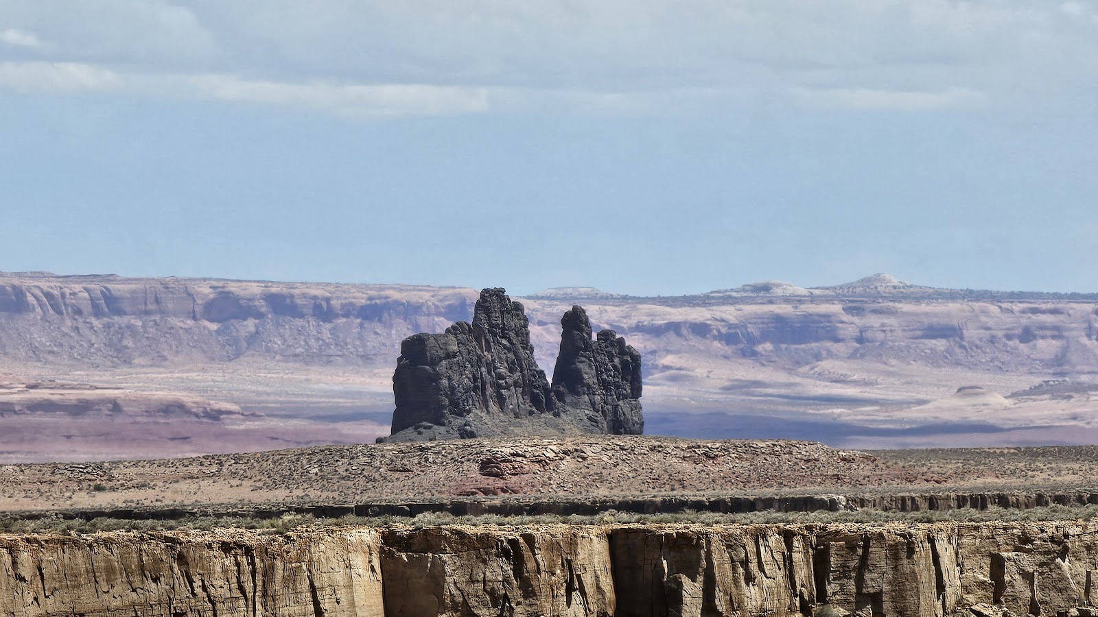 This formation is located on the far side of the canyon.


 While it was raining cats and dogs to the south of us, we weren't getting a single drop.
 I know the Moki Dugway is up ahead of us, but how are we going to get up that mountain?
 Valley of the Gods to the right and the Moki Dugway straight ahead.
 Luckily ROVER, even when fully loaded with two passengers, is still under 8000 lb.
 After the very first switchback the pavement ends and the gravel roadway begins.
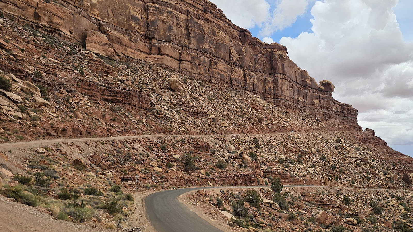 That first long climb doesn't look too steep for ROVER to handle.
 This section of the road is plenty wide for two large vehicles to pass each other.
 We are about halfway to the top now.
 That's a long way back down to the bottom.
 Just around this corner and we'll be on top of Cedar Mesa and the Moki Dugway.
 Now we just have 5-miles of this bumpy dirt road to get to Muley Point.
 From Muley Point you can see the formations in Monument Valley off in the distance.
 This is about 10-miles downstream from our campsite view.
 YEP, that's the same muddy water of the San Juan River down there.
 Some people may be brave enough to walk out onto that flat rock, NOT ME!
 Can you spot the 4 RVs on the opposite rim of the canyon wall?
 They are still there alright, we saw them on the way in.
 We stopped to talk with them on the way out and Tricia texted them her photos.
 A final few shots before we start heading back down to the campground.


 OK, five more miles back down the same dirt road.
 That first curve looks a lot scarier from this angle.
 FYI - There are no guardrails on the Moki Dugway.
 Tricia thought this rock looked like a gorilla face, I have to agree.
 This is the narrowest spot of the Dugway.
 YEAH, pavement, we're almost to the bottom now.
 One more obstacle to avoid, don't those huge rocks look ready to tumble down onto the road?
 This cliff face to the east is just stunning.
 Mother Nature has been hard at work carving this spectacle for us to admire.
 This is the view from the Day Use Area of the park.
 THE POD looks awful lonely sitting over there all by itself.
 That's a pretty wondelful backdrop to photograph with THE POD.


 I'm pretty sure I can name this one.
 It sure looks like a "Lady in the Bathtub" to me.
 I'm guessing "Castle Butte"? I don't know, what do you think?
 Could this be "Battleship Rock"?


 This is one of the "easy" gullies to cross. I wish we had photos of the "tough" ones.


 Could that be "Sitting Hen Butte" off in the distance?


 Up close it looks a little more like a "Sitting Hen" doesn't it?
 I'm not sure who all these people were camping in tents...
 ...but this is BLM land so anyone can camp anywhere out here.
 It's just gorgeous out here in Valley of the Gods.
 It's still pouring rain over on Monument Valley.
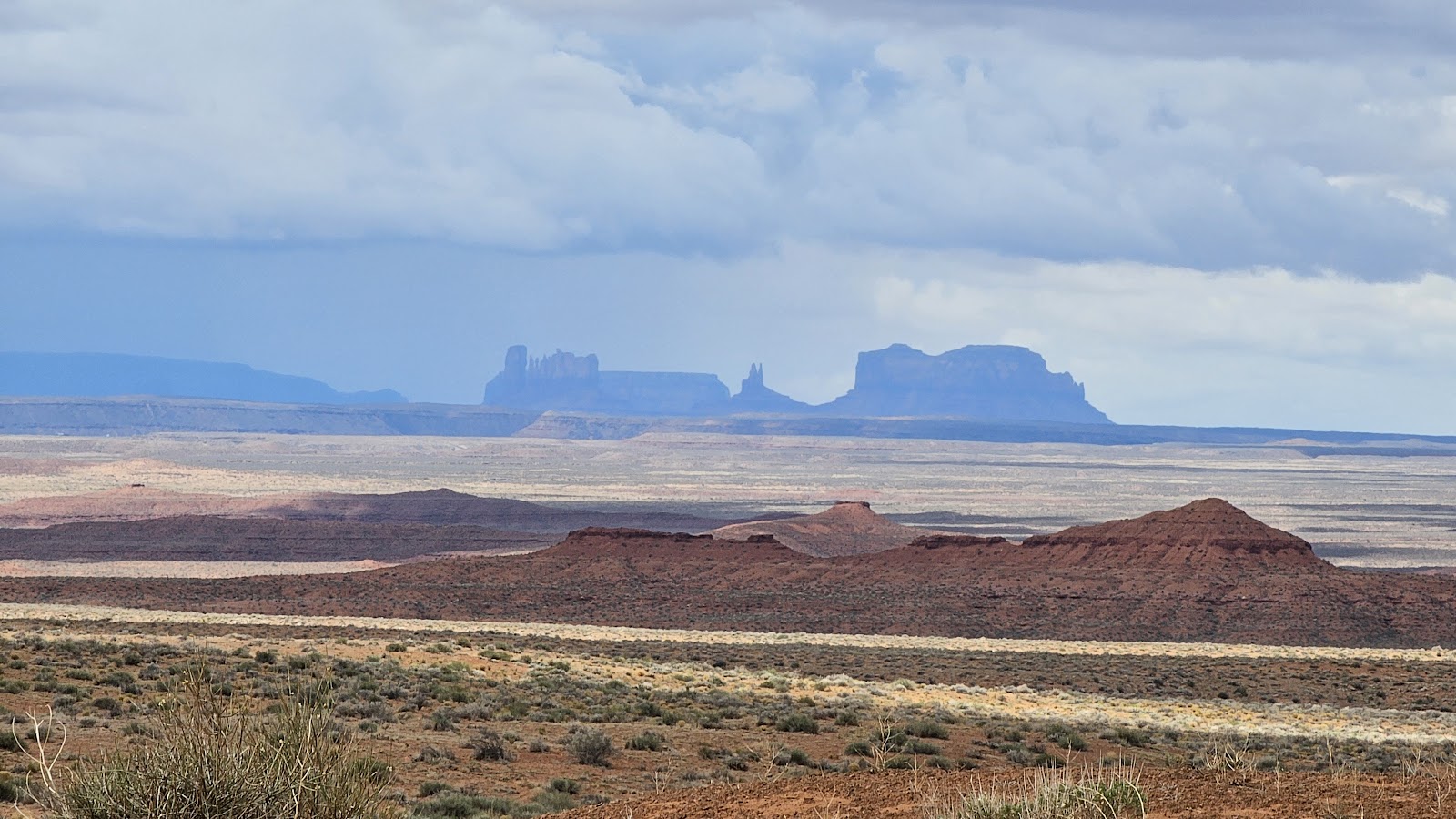


 And finally I think this one could be "Seven Sailors Butte"?


 I don't understand the need to stand in the middle of the road to take your photo.
 It's hard to see, but those people are sitting down in the middle of the road.
 It's not that busy of a road, but the speed limit is 45MPH.
 The road curves around the monuments to the right...
 ...where this large butte with several spires standing on their own is found.
 One day this spire will eventually crumble to the ground, but not today!
 From the back patio of the restaurant you get a bird's eye view of the start of the Scenic Drive.
 The first monument on the drive is one of the most famous, it's called the West Mitten Butte.
 The second monument to come into view is the almost as famous East Mitten View.
 Next door is the Merrick Butte, named after an early prospector in the Valley.
 This is described as Elephant Butte, I don't see it, do you?
 With all the rain they've had this is the worst we encounter on the whole drive.
 This formation is unique in the Valley, it's called The Three Sisters.
 At John Ford's Point (movie director) you could have your photo taken on horseback ($10).
 Here comes one of the $85 a seat "open air" tours.
 They don't look like they're having fun under those dust masks, plus it's 94°F today.
 This one is called Camel Butte, again I don't see it.
 That big raised area is called Rain God Mesa.
 The back side of Rain God Mesa.
 Still Rain God Mesa. What do you want me to say, it's huge!
 With all that sand piled up over there it's easy to figure which way the wind blows.
 These are called the Totem Poles, now that one I completely understand.
 This is described as Yei Bi Chei (translates to Navajo spiritual gods).
 From this point on the road becomes more sandy instead of gravel.

 Underneath this towering mesa ROVER looks rather tiny.
 He doesn't even measure up to one of the boulders that tumbled to the bottom.


 This boulders base has been undercut by wind and rain for centuries.
 Again, ROVER doesn't even come close to measuring up.
 This sandy side road takes you to the Navajo Code Talkers Outpost.
 The view from the Outpost is the most scenic "long range" view we've seen.
 This view is called the North Window. I'd say it frames the view very well.
 This is Spearhead Mesa.
 I call this one "Humpty Dumpty", because there's no way to put it back together again.
 The view from the North Window.
 Last, but not least, this one is called The Thumb.


