MONDAY - This morning we're leaving Grand Portage and heading south a little over 100-miles on Minnesota Highway 61.
This stretch of Highway 61 is known as the North Shore Scenic Drive. It also holds the recognition of being an All American Road.
An "All American Road" must meet two out of six intrinsic qualities (archeological, cultural, historic, natural, recreational, or scenic). The designation means they have features that do not exist elsewhere in the United States and are unique and important enough to be a tourist destination unto themselves.
The North Shore Scenic Drive meets the criteria of being both recreational (thanks in part to the 7 state parks) and scenic (thanks to the numerous waterfalls and the Lake Superior shoreline).
The overall length of "The Scenic Drive" is 154-miles, from Grand Portage in the north to Duluth in the south. We'll being traveling about 2/3 of that distance today and will do the lower 1/3 when we head to our next destination to complete the balance of the route. It hasn't always been Minnesota Route 61 however.
From 1926 to 1991, the road from Grand Portage down to New Orleans was all part of US-Highway 61.
In 1991 the section of US-Highway 61 north of Duluth became Minnesota-Highway 61 and in 2000 gained the distinction of becoming an All American Road called the North Shore Scenic Drive.
"Highway 61" is famous for another reason too. In 1965 Duluth native Bob Dylan used the road to title his 6th studio album "Highway 61 Revisited", which contained a song with the same name. This 6th album also contains his arguably biggest hit song of his entire 65+ year musical career, Like A Rolling Stone.
Bob however was referring to the US-Highway 61 which connects his home town of Duluth, MN to New Orleans, LA. It passes through such musical hotspots as St. Louis, Memphis and the Delta Blues region of Mississippi.
We weren't on the road for more than 15-minutes this morning when we passed by a homesite that has about 200-300' of frontage right on Scenic Highway 61.
The curb on their front yard is quite unique, but I just wonder what they were thinking when they decided to decorate the front yard.
SLIDE NUMBER
1
OF
8
SLIDE NUMBER
2
OF
8
SLIDE NUMBER
3
OF
8
SLIDE NUMBER
4
OF
8
At least they kept the driveway clear.
SLIDE NUMBER
5
OF
8
SLIDE NUMBER
6
OF
8
SLIDE NUMBER
7
OF
8
SLIDE NUMBER
8
OF
8
There were no KEEP OUT signs, but could this pathway be an invite to check things out?
Here's my thoughts if anybody is interested.
The driftwood is all probably salvaged straight off the shoreline of Lake Superior, which is right across the street, but could "all the rest of it" be trash that they also picked up off the shoreline? I doubt it! If it were, it could be their way of making a statement about all the trash that washes up on the shorleine, but would that alone make it ART?
It's not JUNK! First off the house is too well cared for. The "placement" of each piece seems pretty well thought out and nothing looks old or broken. This area recieves 70" of snow in an average year, which is usually paired with some high winds. Nothing is toppled over, so it appears to be well maintained.
So I guess what I'm saying is, YES it's ART, it's just not what I find appealing. It's just too much, too overwhelming! Maybe they've never heard the term "less is more"!
It was a tight fit getting THE POD and ROVER completely into our campsite and clear of the roadway, but with a little creative maneuvering we made it work!
We have quite a few sightseeing opportunities planned from this location and with a less than desirable weather forecast for our time here we decided to drive 20-miles back up Highway 61 to start checking some of them out while it wasn't raining.
CRYSTAL BAY POINT TRAILHEAD AND SEA CAVES BEACH TRAILHEAD
SLIDE NUMBER
1
OF
15
The Crystal Bay Point trail starts out going just about straight up.
SLIDE NUMBER
2
OF
15
When you crest the top of the hill it levels off quite nicely for a while...
SLIDE NUMBER
3
OF
15
...and you get a pretty nice view of the Lake Superior lakeshore. This by the way is where I turned around and headed back towards ROVER.
SLIDE NUMBER
4
OF
15
Tricia however kept going forward and started a slight downhill trek.
SLIDE NUMBER
5
OF
15
It looks like she'll soon run out of real estate.
SLIDE NUMBER
6
OF
15
Two choices here, jump for it and swim or turn around and head back.
SLIDE NUMBER
7
OF
15
She choose to turn around and caught a glimpse of where we're headed next.
SLIDE NUMBER
8
OF
15
Sea Caves Beach is far down directly below us.
SLIDE NUMBER
9
OF
15
The Sea Caves Beach trail starts out heading straight down.
SLIDE NUMBER
10
OF
15
How this solitary huge boulder ended up here is a mystery to me.
SLIDE NUMBER
11
OF
15
After scrambling down some rocks we made it out onto Sea Caves Beach.
SLIDE NUMBER
12
OF
15
Everyday these depressions in the rockface get ever so slightly deeper.
SLIDE NUMBER
13
OF
15
In this photo you can see the Crystal Bay Point that Tricia hiked out to.
SLIDE NUMBER
14
OF
15
That solitary tree about 2/3 the way down is where I turned around.
SLIDE NUMBER
15
OF
15
We will be seeing some more spectacular sea caves this weekend, I promise.
Next stop is a lookout that has a high vantage point to observe the Lake Superior shoreline. This one there's no hiking involved, you can drive right up to the parking lot on the edge of the overlook at Palisade Head.
Next stop is the town of Silver Bay. It is here that you'll find the Northshore Mining Company and their mascot, Rocky Taconite. The mineral taconite is used to make iron and steel and there's a huge processing plant here just outside of town. Right behind the processing plant is what's called Black Beach. Why it's called Black Beach I don't know, it looks just like the other beaches around here. I guess I was expecting a beach like you see in all the Hawaii black beach photos.
Meet Rocky Taconite!
Does this look like a Black Beach to you?
Next stop is Beaver Falls. The Beaver River travels nearly 26-miles from it's headwaters before empting into Lake Superior. From the Highway 61 Bridge you can see the river drop 300-feet over a series of falls and cascades before passing under the bridge.
It's 6:30PM now and passed my dinner time. After several failed attempts to find someplace open for dinner we finally had to drive several miles up Highway 61 before we found a Bar & Grill still open. Outside of the building Tricia spotted this groundhog hanging around the outdoor patio. I have a feeling he's living under the deck.
Just 7-miles north of Gooseberry Falls State Park, where we're camped, is the Split Rock Lighthouse. It has a museum and tour of the lightkeepers quarters that's open to the public, but they close at 6:00PM and it's nearly 7:45PM right now.
For today, we'll have to settle for this long range photo from the Scenic Pullout off the highway, but we intend to get closer and take some more photos.
We still have a couple of spots to check out, including a closer look at the Split Rock Lighthouse, a pink sand beach? and the falls right here at Gooseberry Falls State Park.
All of that will probably have to wait until Wednesday when it finally stops raining!
WEDNESDAY - We left THE POD around 7:30AM to head 13-miles south into the town of Two Harbors, MN to eat breakfast.
On the way there we passed through not one, but two, rather short tunnels on Minnesota Highway 61.
The Lafayette Bluff Tunnel opened to traffic in 1991.
The Silver Creek Cliff Tunnel opened to traffic in 1994.
Before these two tunnels were completed, traffic had to go around these two cliff areas which were constantly prone to falling boulders which would close the highway for hours or days at a time. With no other short detours around these two cliffs that was a problem.
After breakfast we went across the street to pick up a few grocery items and then headed north for the Split Rock Lighthouse. Today we're each going to pay the $15 fee to climb up into the short lighthouse and check out the museum plus the rest of the grounds.
SPLIT ROCK LIGHTHOUSE AND MUSEUM
SLIDE NUMBER
1
OF
19
After watching an informative 13-minute film about the reason for this lighthouse and the difficult construction of it we finally got a closer view of it.
SLIDE NUMBER
2
OF
19
The reason the lighthouse is so short is because it's base is 130' high up on a cliff.
SLIDE NUMBER
3
OF
19
It was completed in 1910 and retired from service in 1969.
SLIDE NUMBER
4
OF
19
The original oil vapor bulb has been replaced with an LED light and is only lit one day a year.
SLIDE NUMBER
5
OF
19
Every November 10th a ceremony commemorating the day of the sinking of the SS Edmund Fitzgerald is held. The light is lit at 4:30PM and the names of all 29 crewmembers are read to the tolling of a ship’s bell.
SLIDE NUMBER
6
OF
19
The SS Edmund Fitzgerald passed by this lighthouse early into it's final voyage in 1975.
SLIDE NUMBER
7
OF
19
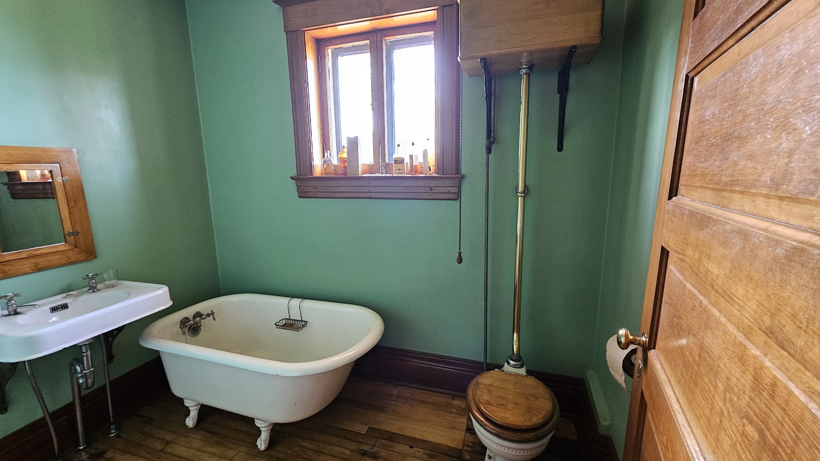
We were also able to tour the inside of one of the lightkeepers homes.
SLIDE NUMBER
8
OF
19
A very knowledgeable docent was there to answer all our questions.
SLIDE NUMBER
9
OF
19
We were informed that the interior had been setup to look like it was in the 1930s.
SLIDE NUMBER
10
OF
19
SLIDE NUMBER
11
OF
19
SLIDE NUMBER
12
OF
19
SLIDE NUMBER
13
OF
19
SLIDE NUMBER
14
OF
19
SLIDE NUMBER
15
OF
19
SLIDE NUMBER
16
OF
19
SLIDE NUMBER
17
OF
19
SLIDE NUMBER
18
OF
19
This is said to be the most photographed location in all of Minnesota.
SLIDE NUMBER
19
OF
19
We especially liked this view from down on the beach. It was a hike to get down there!
The LED light is not on, that's just sunlight reflecting off the Fresnel Lens.
I guess I should have read the fine print when I thought we were about to explore a "pink sand" beach here on Lake Superior.
It was pink, I'll give it that, but it's a mighty coarse "sand" they have here.
Iona's Beach Scientific & Natural Area is a state operated area so you'll need a park pass.
It's after noon now so that means it's time to head back to the campsite for lunch. Then we'll take care of visiting our final sightseeing destination, Gooseberry Falls, right here in the same park where we are camped.
Unlike our last post, I do believe this time we saved the best for last. Note that the photos don't really give you the feel of what it was we experienced. Wait until you check out the videos after the slideshow.
THE RAGING WATER AT GOOSEBERRY FALLS
SLIDE NUMBER
1
OF
17
Once again these falls are only about a quarter mile walk from the parking lot.
SLIDE NUMBER
2
OF
17
To say the water was raging is a huge understatement.
SLIDE NUMBER
3
OF
17
We were told by others that on Monday there was a walkway down there.
SLIDE NUMBER
4
OF
17
Others told us on Monday they walked over to that window in the rock.
SLIDE NUMBER
5
OF
17
The water was so high that the local NBC TV station had a camera there to recond the action.
SLIDE NUMBER
6
OF
17
These are the Middle Falls and were easy to get up close to the raging water.
SLIDE NUMBER
7
OF
17
This viewpoint shows the water plunging over the Middle Falls.
SLIDE NUMBER
8
OF
17
Just a few yards upstream the choas was out of view, but could still be heard.
SLIDE NUMBER
9
OF
17
The upper falls are on the other side of the Highway 61 bridge. Tricia spotted the pedestrian bridge located underneath the highway span.
SLIDE NUMBER
10
OF
17
These are the Upper Falls on the Gooseberry River.
SLIDE NUMBER
11
OF
17
From atop the Upper Falls you can see the Highway 61 Bridge.
SLIDE NUMBER
12
OF
17
Here's the pedestrian walkway underneath the roadway bridge.
SLIDE NUMBER
13
OF
17
View of Upper Falls from the pedestrain bridge.
SLIDE NUMBER
14
OF
17
The view downstream of the Middle and Lower Falls
SLIDE NUMBER
15
OF
17
After seeing all that muddy water flowing over the falls it explains this photo Tricia took during her morning walk. This is where the Gooseberry River empties into Lake Superior.
SLIDE NUMBER
16
OF
17
You can definitely see the muddy water mixing with the clear water of the lake.
SLIDE NUMBER
17
OF
17
That's a huge muddy slick of water out in the lake.
I'm wondering if either of these two trees will be there by the end of the week?
I sure wouldn't want to fall into that rushing water!
The Middle Falls is where most people were hanging out.
The Middle Falls is also where the TV news camera was stationed.
Not to be out done, the Upper Falls also had a crowd watching.
When you get up close you can "feel" how fast the water is moving.
A view of the Upper Falls from under the Highway 61 Bridge.
Watching the water running downstream towards Lake Superior.
While watching all that water flowing towards Lake Gitche Gumee (the Objiwe people's name for Lake Superior which means "Big Sea" or "Huge Water") I heard a local old-timer saying that he has lived here his whole life and hasn't seen the water this high in over 50-years.
I guess that's why the TV news camera was here! It's Big News when an event like this occurs.
All of this is thanks to yesterday's all-day rain that was added to the other rainy days we've had over the last 10-days.


 At least they kept the driveway clear.


 There were no KEEP OUT signs, but could this pathway be an invite to check things out?


 The Crystal Bay Point trail starts out going just about straight up.
 When you crest the top of the hill it levels off quite nicely for a while...
 ...and you get a pretty nice view of the Lake Superior lakeshore.
 Tricia however kept going forward and started a slight downhill trek.
 It looks like she'll soon run out of real estate.
 Two choices here, jump for it and swim or turn around and head back.
 She choose to turn around and caught a glimpse of where we're headed next.
 Sea Caves Beach is far down directly below us.
 The Sea Caves Beach trail starts out heading straight down.
 How this solitary huge boulder ended up here is a mystery to me.
 After scrambling down some rocks we made it out onto Sea Caves Beach.
 Everyday these depressions in the rockface get ever so slightly deeper.
 In this photo you can see the Crystal Bay Point that Tricia hiked out to.
 That solitary tree about 2/3 the way down is where I turned around.
 We will be seeing some more spectacular sea caves this weekend, I promise.


 After watching an informative 13-minute film about the reason for this lighthouse
 The reason the lighthouse is so short is because it's base is 130' high up on a cliff.
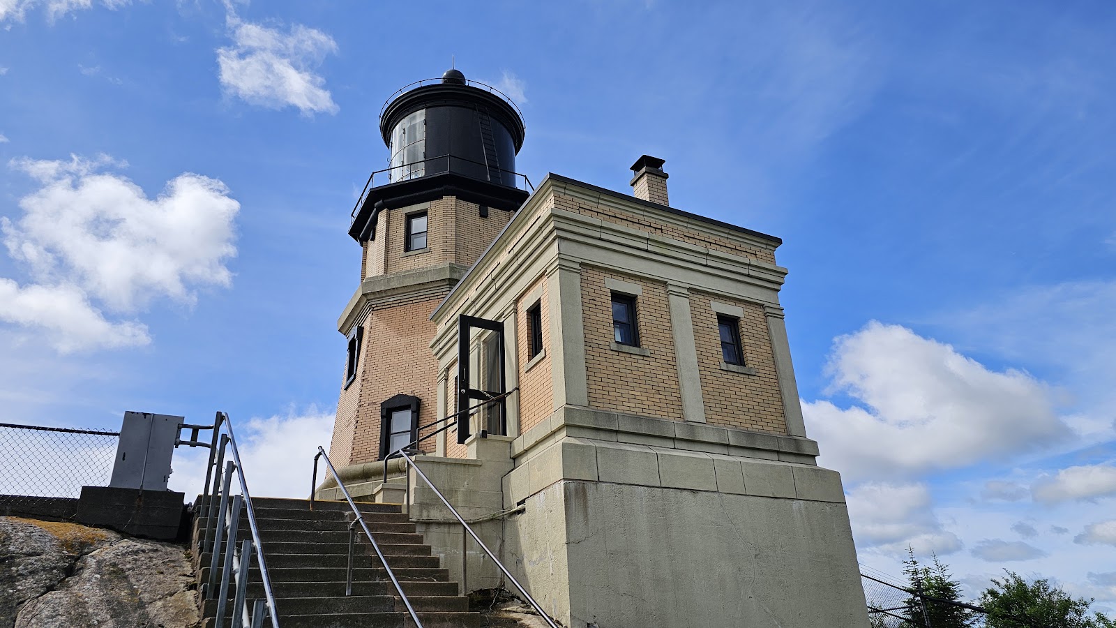 It was completed in 1910 and retired from service in 1969.
 The original oil vapor bulb has been replaced with an LED light and is only lit one day a year.
 Every November 10th a ceremony commemorating the day of the sinking
 The SS Edmund Fitzgerald passed by this lighthouse early into it's final voyage in 1975.
 We were also able to tour the inside of one of the lightkeepers homes.
 A very knowledgeable docent was there to answer all our questions.
 We were informed that the interior had been setup to look like it was in the 1930s.


 This is said to be the most photographed location in all of Minnesota.
 We especially liked this view from down on the beach. It was a hike to get down there!


 Once again these falls are only about a quarter mile walk from the parking lot.
 To say the water was raging is a huge understatement.
 We were told by others that on Monday there was a walkway down there.
 Others told us on Monday they walked over to that window in the rock.
 The water was so high that the local NBC TV station had a camera there to recond the action.
 These are the Middle Falls and were easy to get up close to the raging water.
 This viewpoint shows the water plunging over the Middle Falls.
 Just a few yards upstream the choas was out of view, but could still be heard.
 The upper falls are on the other side of the Highway 61 bridge.
 These are the Upper Falls on the Gooseberry River.
 From atop the Upper Falls you can see the Highway 61 Bridge.
 Here's the pedestrian walkway underneath the roadway bridge.
 View of Upper Falls from the pedestrain bridge.
 The view downstream of the Middle and Lower Falls
 After seeing all that muddy water flowing over the falls it explains this photo Tricia took during her morning walk. This is where the Gooseberry River empties into Lake Superior.
 You can definitely see the muddy water mixing with the clear water of the lake.
 That's a huge muddy slick of water out in the lake.