THURSDAY - Even though we only have a short 80-mile commute between campgrounds today we had to plan everything around the weather.
We got a break in the rain at around 11:00AM so we quickly broke down the campsite, hitched up ROVER to THE POD and got on the road. We weren't very far down the road when the rain returned, but the forecast is for it to rain most of the entire day.
The roads were wet and the traffic was light, so we kept it well under the speed limit.
There were quite a few large farming operations going on in this region of Iowa.
Most farms had plenty of silo storage for after the corn is harvested.
There was also a large processing plant along our route today.
Iowa grows more corn than any other state, but they have room for a few sheep too.
The only town of any size that we passed through today was Manchester (pop. 5,065) which apparently is just large enough to warrant a "non-Supercenter" Walmart. This store was larger than the typical Walmart Neighborhood Market store and it did sell clothing, electronics and automotive merchandise, but there was no deli counter or bakery to be found.
Fortunately for us it did have one stand alone freezer case filled with ice cream treats and among them were a few 6" Carvel Ice Cream Cakes, exactly like the one Tricia has been requesting for her birthday.
Since we had a visit to a Costco earlier this week there is no room in our small freezer, which means we both had Carvel Ice Cream Cake for lunch today, right there in the back of the Walmart parking lot!
As we got closer to our destination the clouds began to break up and the sun even tried to peek out just long enough for us to get setup again. We'll be here for a full week, so it was time to set up the anemometer and Starlink dish so we have something to do inside THE POD during the days of rain we're expecting.
FRIDAY - Tricia woke up early today to do her morning walk and found the entire park under a cover of dense fog.
It made for some very interesting photos that I thought I'd share with you all. All of these photos were taken between 6:30AM and 7:00AM.
EARLY FRIDAY MORNING WALK
 These two were spotted before Tricia even left our campsite.
 One last look back before disappearing over the ridge.
 Two geese down by the South Lake picnic area.
 One of the two man-made spillways that creates South Lake.
 You two are getting awfully close to the edge of that spillway.
 Downriver from the spillway is an eddie where all the froth gathers and spins in circles.
 Further downriver the water appears to settle down a bit.
 This riverside plant is soaking up all the morning dew.
 It won't be thirsty for the rest of the day.
At precisely 10:00AM this morning I had a camping reservation to make for a state park in Arizona for next May, that's right, we do plan our travels that far in advance. Afterwards, at the much more reasonable hour of 10:30AM, we climbed into ROVER and headed out to explore the rest of this "Top Rated" Iowa State Park.
Dedicated in 1920, Backbone State Park is Iowa's first state park. It's named for the steep and narrow ridge of bedrock cut by the Maquoketa River as it flows through the park, which creates what's known as "The Devils Backbone".
Backbone State Park has four separate entrances (North-South-East-West). The South Entrance, where we came in, is isolated from the rest of the park, i.e. it's a dead end. To me that sounds like the perfect place to put a campground and that's exactly what they did.
The other three entrances (North-East-West) are all connected by roadways through the park which is where you'll find many of the hikes, the fishing opportunities, the picnic grounds and the Civilian Conservation Corps (CCC) museum. The three entrances all meet near the middle of the park at a T-intersection, where you'll find a large picnic area.
We drove out the South Entrance and made our way north up to the East Entrance and reentered the park.
Here are some photos of our time exploring the rest of the park today.
DRIVING TOUR OF THE PARK
 This "frog" was just outside of the South Entrance in a neighbors front yard.
 South Lake (left is the Boat House and center is the Lodge, both CCC built).
 A closer view of the boat house from the rear.
 The scenic overlook just inside of the East Entrance.
 This antique viewing scope can be found at the Scenic Overlook.
 One of the winding and twisting roads found in the park.
 There were five of these high water crossings along our route today.
 CCC stonework found outside of the 1925 Trout Fish Hatchery which closed in 1988.
 The CCC built auditorium is still in use today.
 It has electricity and a large open air stage in the front...
 ...with plenty of seating for everyone to be comfortable.
 These "Red Admiral" butterflies could be found everywhere in the park today.
 Inside the North Entrance of the park is where you'll find the Richmond Springs picnic area.
 The only visitors to the picnic area today (besides us) were two pair of Canadian Geese.
 This is what Richmond Springs looks like today.
 From above you can still see the foundations of two man-made pools.
 It seems a waste of all this space for just us and the four geese.
 Inside the old park headquarters is where you'll find the CCC Museum.
 Behind the museum is the old barn.
 This is an old color photo of Richmond Springs in it's heyday of the 1960s.
SUNDAY - We arrived here on Thursday afternoon to a campground with 50-sites that have electric hookups and 50 more that don't.
From our site, located up in one corner, we can see all 50 electric sites from our rear dinette windows. Upon our arrival on Thursday there were about 10-campsites that were occupied.
By late afternoon on Friday there were probably 35 of the 50 sites with campers on them and it remained that way until Sunday afternoon when the count quickly dropped down to just 4 and that included us and the campground host.
More and more often I prefer it when the campground is quiet and void of the weekend crowds. Since the crowds have left we've seen deer and wild turkey venture back out into the open areas of the campground for our visual pleasure. We've even had a couple of hummingbirds buzz by our back windows as if to say hello.
MONDAY - After staying put inside of
THE POD for the weekend, Tricia decided today was the day she was going to attempt the 6-mile long hike around the lake.
With it being sunny and no chance of rain, and a high of only 75°F, the weather today is perfect for the hike. When Tricia started her hike at around 8:30AM the tempurature was around 55°F, but we've seen that it warms up pretty quickly around here when the sun is out.
 The hike started and ended right at our campsite (Orange Circle #1).
Using her Garmin In-Reach Mini GPS Tricia sends me her coordinates by text and email every 30-minutes so I can plot them using Google Maps and I'll know exactly where to start looking for her if she stops reporting in. It's the safest way we've figured out for her to hike alone when she goes on hikes of more than 3-miles. Anything under a 3-mile hike and I'll usually join her on the trail, not that that's much safer.
HIKING IN BACKBONE STATE PARK
 Once outside of the campground it didn't take long to reach the shoreline.
 This region of Iowa is very hilly.
 There were several obstacles along the trail.
 Here the trail starts to climb up to a ridge.
 Several different varieties of flowers were seen today.
 These are "Mica Cap" Mushrooms and are rumoured to be quite tasty.
 We've seen campers in both of our Iowa campgrounds heading into the woods
with a disposable grocery bag in hand, presumably looking for these tasty treats.
Guess they missed these here!
 These purple flowers were identified as "Sweet Violets".
 This bridge was spotted from quite a ways off.
 The placard on the handrail says "10,000 lb. capacity". That's enough to hold ROVER!
 Looking upstream from the center of the bridge.
 Looking downstream from the end of the bridge.
 Nary a cloud in the sky, what a perfect day for a hike!
 I've identified these lavender colored flowers as Wild Blue Phloxes.
 Here is where the trail emerges into the rear of the Six Pines Campground.
 Another trail obstacle to overcome.
 Yet another man-made bridge out in the middle of the woods.
 Tricia said this bridge felt a "little rickety" and felt it would not hold more than 300-lbs.
 Here a "hole in the wall" lets you catch a glimpse of the lake down below.
 This is part of the "Backbone Section" of the trail.
 These flowers identify as part of the Honeysuckle Family.
 This intersection I'm familiar with. It's were the East-West-North entrance roads all meet.
 At the East Lake trailhead is where you'll find this elaborate bathroom building.
 Finally heading back south towards where THE POD and I are waiting.
 There were several locations where a cliff overhung the route on the East Lake Trail.
 This one at least had a stone bench where you could rest at it's base.
 Looks like we're heading up and away from the shoreline here.
 YEP! That's a little ways down to the shoreline.
 Here the trail comes down, just in time to go back up again.
 More of those Wild Blue Phloxes
 Back down at the shoreline it was beginning to get a little warm and humid...
 ...but these two Canadian Geese know how to cool off.
 More of the winding shoreline trail to follow before she runs into...
 Here's another one of those Red Admiral butterflies that are so common here in the park.
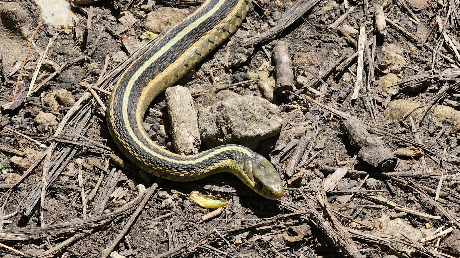 RUT ROH! Do garter snakes eat butterflies? I'll have to look that up on Google.
 Another obstacle avoided and time to get back to hiking the trail.
 Another rickety bridge up ahead.
 The only thing holding up that right hand railing is the nearby tree.
 Now what kind of animal does that? Tricia thinks it's a beaver. What do you think?
 More honeysuckle blossoms.
 This is the Day Use Area over by the Camping Cabins.
 Another photo of the boat house.
 A 180° view of the lake from up in the turret.
 I believe they offer kayak and canoe rentals here in the summer.
 This is the swim beach area next to the boat house.
 Not sure what this area is for, but you can see the boat ramp on the far shoreline.
It took Tricia nearly 4½-hours to traverse her 6½-mile hike today. It took me nearly the same amount of time to look through the 167-photos she took along the trail and pair it down to the 50-photos I shared with you in the slideshow.
But after selecting the photos to share my job is only half done. I still need to straighten, crop, upload and caption the photos, then write a little storyline to go with them. I'd also like to mention that I've never color corrected any photos you've seen on this blog. What you see is what the camera gave us!
Just because we are both retired now, it doesn't mean the work has ended, it's just shifted into a different direction for us.
TUESDAY - It was just Sunday afternoon when I was touting how nice is was being just one of four occupied campsites here in the park. Well this afternoon my zen bubble got burst when two 15-passenger vans full of kids and adults, along with two pickup trucks, one towing a 25-foot camper and the other a 10-foot cargo trailer pulled up right across the street from us and began earnestly setting up camp before the afternoon thunderstorms were upon us.
That's right, at least 40-people were now within a few yards of our back windows. Less than an hour later there was no one to be seen across the street. They had all piled back into the vans and pickups and left the campground, presumably to go explore the park.
Here's what their camp set up looked like while they were gone exploring.
The good news is they only reserved one night,
so they should be gone by this time tomorrow.
WEDNESDAY - Since it's our last full day here in Backbone State Park I guess it's only right that I get out on the trails myself.
We saved what is considered the best trail in the park, which also happens to be one of the shortest trails in the park.
The Backbone Trail is only ¾-mile long and relatively flat, with scenic vistas looking down upon the river from a high vantage point. That sounds exactly like the kind of hike I would enjoy.
THE BACKBONE TRAIL
 Ready to get started? Only two other cars at the trailhead, yeah!
 The trail starts out easy enough, but watch out for those rocks and tree roots.
 I'd estimate that to be at least 40-50 feet down to the river.
 Maybe even higher at this location.
 Here is where you really have to start paying attention to where you place your feet.
 Just beautiful!
 Come on Tricia! I can't go any slower or I'll fall over.
 A few locations have access to the shoreline down below.
 It's not comfortable, but it'll do in a pinch.
 These identified as Hoary Puccoon flowers.
 My favorite trail photo always includes...
 ...a view of ROVER waiting for us in the parking lot.
Now that I've fulfilled my hiking quota for the week, let's go find some lunch.
The town of Strawberry Point is just a few miles north of the park, and even if we can't find lunch there they do have the World's Largest Strawberry in town.
Since the late 1960s this 15' tall strawberry has sat above the City Hall/Police building.
It looks just as delicious today as it did in the 1960s doesn't it?
The Franklin Hotel dates back to the early 1900s and legend has it the ghost of a 1920s prostitute named Lily can be heard singing and wandering the halls still today.
We ended up grabbing subs at the Subway inside of the gas station before we headed out to one last sightseeing destination for today.
Outside of the small town of Edgewood, IA (pop. 913) is where you'll find the Bixby State Preserve and The Ice Cave. The cave site gained national attention back in the 1970s when a small snail that was thought to be extinct for thousands of years was found thriving there thanks to the unique microclimate.
Less than ½-mile passed this entrance sign the road will cross Bear Creek.
It's all a one lane road with just enough room to pass a car coming in the opposite direction.
Immediately passed Bear Creek is a pinic area on the right. Park and make your way to the very back of the picnic area where you'll see this rock pathway that crosses the creek.
Once across the creek go 250' down the trail and on the right you'll see the stone stairs and wooden handrail leading to the cave entrance. Less than halfway up these stairs you'll feel the temperature drop several degrees with each step.
There are more stairs leading above the cave entrance, but we didn't explore any further.
Standing at the cave entrance I'd guess the air tempurature was in the lower 40°Fs.
Looking inside didn't reveal much to see.
This is more of a sightfeeling location than a sightseeing one.
Would you like to be notified of new blog posts?