

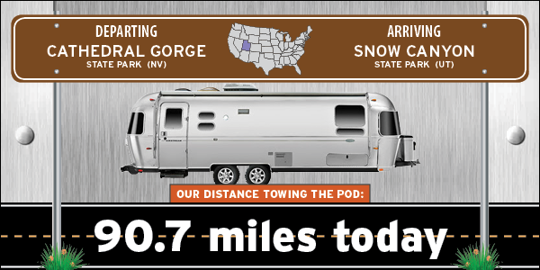
With a little less than 100-miles to travel today we waited until 11:00AM before hitting the road. The first order of business was to dump our holding tanks. It's been 10-days since we last did that and well, let's just say it's time!
By waiting until later in the morning to hit the road and traveling mostly east and then south we had the sun shining in ROVER's windshield all day. That made it nice and warm inside the cab, but nearly impossible to avoid the glare when trying to take photos through the windshield.
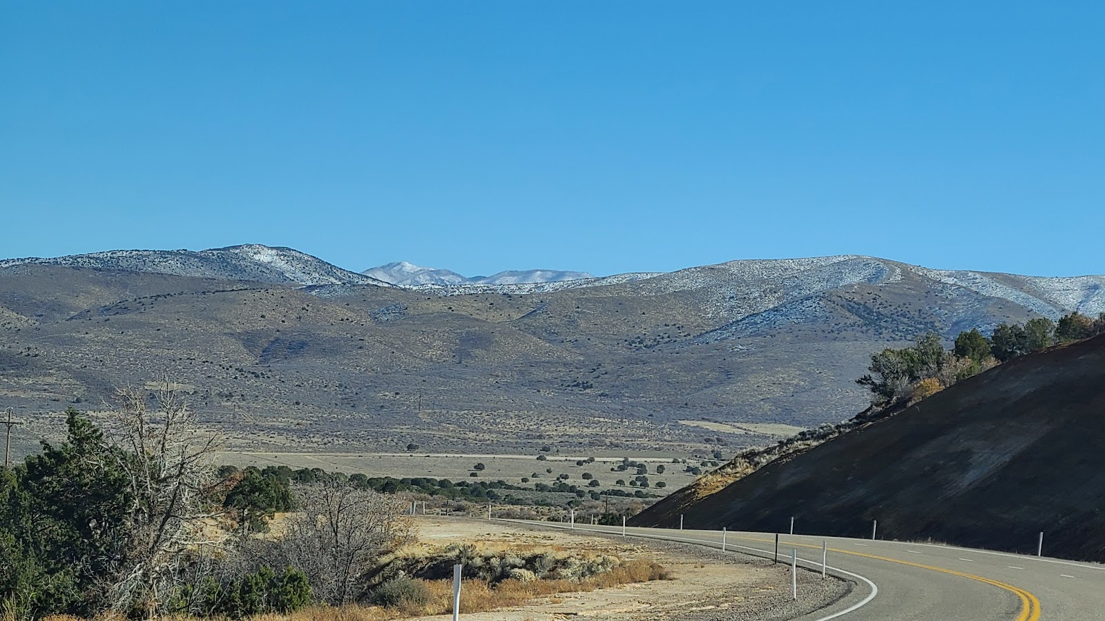
We had two mountain passes to travel up and over to get back into Utah, both of them were just over 6100-feet in elevation. Here's a photo just after passing through the second one which opened up into a wide valley.
Immediately after we turned off the highway and passed through the State Park Entrance Gate we began to descend into Snow Canyon. This is where the ordinary forested mountains and hillsides gave way to the red rock and clay canyon walls.

After getting checked in at the campground office we "squeezed" into our campsite. At least we are on the end of the row and only have one neighbor to get friendly with.
Not all of the campsites in this park are this tight, only Campsites 1-14 with the water and electric hookups are laid out this way. The rest of the sites are much nicer, but they don't have hookups like these do.


SPOILER ALERT: We'll be seeing more of these later this year.

In order to get everything done before lunchtime we'll have to get an early start. What better way to begin a day than eating breakfast at one of Tricia's favorite restaurants, First Watch.
Tricia's ordered her usual, a Chickichanga and I selected one of their seasonal specials, the Pork Green Chile Hash. I also ordered a side of their Biscuit & Turkey Sausage Gravy, because I know their portions are all "Healthy Sized".
Next was a trip to Home Depot for a storage container that fits our new Starlink satellite dish, followed by a trip to Walmart to refill two of our 3-gallon water bottles. Next up a spin through the ATM at the bank to obtain some cash and then the dredded (by me) trip to Costco for groceries, gasoline and propane.
It's nice to sometimes be "just outside" of a larger city so everything you need can be found within a relatively short drive from the campsite.
With everything done it was time to head back to the campsite to set up the Starlink dish and start the process of updating the stats on the blog and beginning a new post for you all.

If I haven't said it before, I'm going to say it now, "I don't like to hike!" just for the sake of hiking. I much prefer to be rewarded with a beautiful scene, like a waterfall, a slot canyon or any natural wonder. Too many times I've done hikes in the woods where after 15-miutes of enjoying the fact that I'm outdoors, I begin to feel like I'm on a "march" instead of a hike and just wish it were over with.
Today's hikes both had rewards awaiting us at the end of the trail. One small reward and one big reward, but rewards none the less.
But before we go out hiking I want to share a photo of a very interesting looking RV that drove past our campsite this morning. I've never seen one of these before and I bet you haven't either.
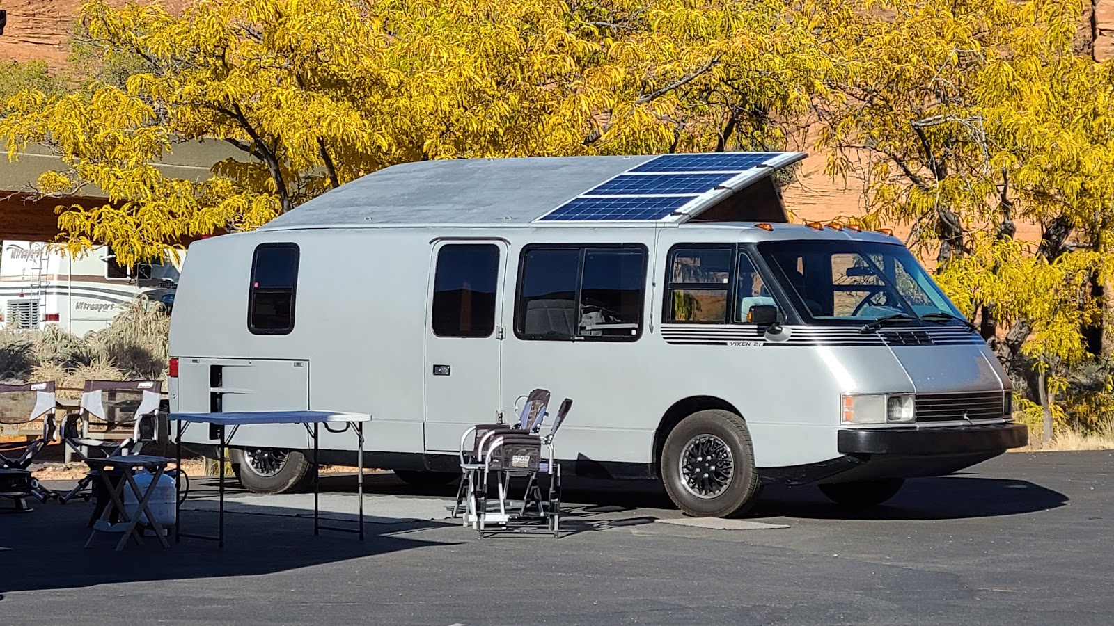
They had a Renault 5 speed manual transmission, with the front suspension, power steering, and power brakes all being GM parts. It also came equipped with the Cadillac automatic level air ride system.
They truly were a unique design for the times, much like the very sought after GMC Motorhomes that were produced between 1973 and 1978, coincidentally also manufactured in Pontiac, MI.
JENNY'S CANYON TRAIL

|
||||||||
 This short ½-mile trail started off easy enough, soft sand and level terrain.
|
||||||||
 We even crossed over a couple of "washes" where the water flows
through the park during the rainy season.
|
||||||||
 It wasn't long before we were entering the slot canyon located at the end of the trail.
|
||||||||
 There were a lot of eroded holes in the side of the canyon
and a lot of small bird feathers all over the ground.
I'll bet the local cliff swallows use these as nests during nesting season (FEB-SEPT).
|
||||||||
 Just a short distance in we reached the abrupt end to the narrow canyon.
|
||||||||
 Turning around and looking out shows you just how short this slot canyon is.
|
||||||||
 Ahhhh! Back out into the warm sunshine.
|
||||||||
 As a bonus to the hike there is another short spur trail
that leads up to an overlook of the slot canyon and surrounding area.
|
||||||||
 Only thing left to do now is hike back to ROVER and go explore the next trail in the park.

JOHNSON CANYON TRAIL

|
||||||||
 Once again a very easy start on level sandy terrain.
|
||||||||
 Somewhere over in that mountainside is a reward waiting for us.
|
||||||||
 This is the southern "open end" of Snow Canyon.
|
||||||||
 It is filled with ancient lava fields from long ago.
|
||||||||
 This is possibly my favorite view of the uplifted mountains.
|
||||||||
 Johnson Canyon Trail is a spur trail off of the much longer Scout Cave Trail
that we won't be doing.
|
||||||||
 Once on the Johnson Canyon Trail we started making our way over
towards the base of the mountains.
|
||||||||
 Those are some mighty large boulders that have come tumbling down the mountain.
|
||||||||
 I'll bet there is a beautiful waterfall coming off that cliff during the rainy season!
|
||||||||
 Our trail continues on around the base of the mountain.
|
||||||||
 Check out the brilliant yellow fall colors of the cottonwood trees.
Also notice how close the residential areas of Ivins, UT
is encroaching on the southern State Park boundary.
|
||||||||

|
||||||||

|
||||||||
 As we wander around this bend we begin entering a wide canyon.
|
||||||||
 We can hear a bubbling spring down in the canyon, but can't see it from the trail.
|
||||||||
 From far away I was wondering why they would erect a fence
way out here in the middle of nowhere.
|
||||||||
 When we arrived at the fence the reason came into view.
It was to warn people not to leave the trail to try and climb up into the 200' wide arch.
|
||||||||
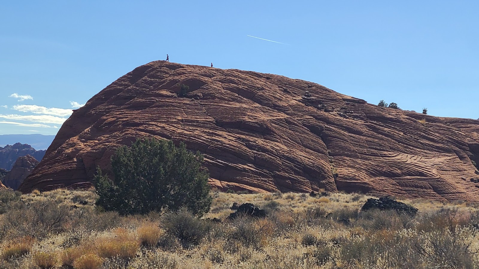
 This is the big payoff I was hoping for! Just beautiful!
|
||||||||
 But we're not done yet, we haven't reached the end of the Johnson Canyon trail.
|
||||||||
 Use your imagination! What do you see in this picture?
|
||||||||
 Now we're at the end of the trail.
Nowhere to go but up or turn around and leave the way you arrived.
|
||||||||
 Yeah, I'm not trying to climb my way out of here.
|
||||||||
 Before heading out we checked out the red rock illuminated by the sun.
|
||||||||
 One last look as we pass by the arch on the way out.
|
||||||||
 Nothing left but hiking the one mile back to ROVER.
|
||||||||
 Almost done! Lookin back, what a spectacular experience.
After our hikes today we headed into town to pick up a few forgotten grocery items at the very fancy (and pricey) Harmon's Grocery store (think Whole Foods atmosphere). Well, $94 later we left the store and treated ROVER to a trip through the automatic carwash located in the parking lot.
On the way back into Snow Canyon near sunset the mountain walls just "glowed red" and I can see why residents would want to live here with these magnificent views.


Today, much like yesterday, we have one very short hike to do first before tackling the longer and more strenuous trail.
I hesitate to even call this first outing a hike. It's a little less than 100-yards out to the end of the trail and then you double back to the parking lot. At least there was a small reward waiting for us at the end of the trail.
TORTOISE WALK TRAIL

|
||||||||
 This recently updated trail was very short and completely covered
with loose pea gravel which made for a very comfortable walk.
|
||||||||
 Before we knew it we were at the end of the Tortoise Walk trail.
|
||||||||
 The purpose for this trail is to bring awareness of the Mojave Desert Tortoise
that inhabit this region of the park.
|
||||||||
 They survive here year round with the 117°F summers,
the freezing winters and a minimal 7½-inches of rain annually.
|
||||||||
 It was obvious the trail previously continued on from this point,
but now that area is off limits to try and protect the tortoise's habitat.
|
||||||||
 Turning around to head back to the parking lot we saw the White Mountains
that the north end of the park is known for.
|
||||||||
 They are entirely different in color and texture than the Red Mountains
at the southern end of the park.
The second outing actually began right across the street from our campsite, isn't that convenient!
I'm calling this one a "combination hike" because we did portions of several different trails. Rather than stay on one trail, at each intersection we changed trails and pieced together a custom route that took us to a wonderful overlook. All together is was just a little over 2-miles when we got back to the campsite.
COMBO TRAIL HIKE

|
||||||||
 This trail began by crossing through a lava field.
|
||||||||
 I began to worry when it looked like the trail would lead us up and over this mountainside.
|
||||||||
 Fortunately there was a hidden secret passage through the mountain.
|
||||||||
 Even so, it was a little rough going.
|
||||||||
 Still trying to get through this secret passage.
|
||||||||
 Once through we immediately started climbing up in elevation.
|
||||||||
 Sometime in the past these large perforated boulders came tumbling down the mountain.
|
||||||||
 Once over the ridge we could see there was another entire valley on the other side.
|
||||||||
 This is one of the parks Petrified Sand Dunes.
|
||||||||
 That's the trail we're following on the right hand side of the photo.
|
||||||||
 Another great view of the valley below
and there were rocks here that made a perfect bench for taking a rest.
|
||||||||
 Somewhere over there is our destination.
|
||||||||
 Odd rock layers surrounded us. Red with blacks tops and the red and white striped tops?
|
||||||||

|
||||||||
 How those two black chunks got up there I don't know!
|
||||||||
 Another valley view with a backcountry trail in the background.
|
||||||||
 Here I am heading for our final destination, the top of the observation point ahead of us.
|
||||||||
 But before I get there I just had to stop and admire the scenery.
And just maybe catch my breath!
|
||||||||
 The view looking north from the observation point.
|
||||||||
 Here is the back side view of the top of the observation point.
|
||||||||
 And the front side shows it's hollow underneath.
|
||||||||

|
||||||||
 From up here we can see THE POD waiting for us back at camp.
|
||||||||
 Time to start heading back down the way we came up.
|
||||||||
 Sometimes it's not so easy to figure out where the trail actually is.
|
||||||||
 Other times it's clearly marked where to go.
|
||||||||
 We're halfway back to THE POD now and I'm getting hungry.
Maybe tomorrow we'll do one more trail. I say maybe because it's forecast to be even a few more degrees cooler. That means it won't reach 50°F tomorrow. Boy am I glad that both of our next two moves are not only further south but also at lower elevations!

It's only 11:00AM and the temperatures are already up to 52°F from an overnight low of 33°F. That means that right after lunch we'll be heading out to do one last hike.
This time we've selected the 2-mile long Butterfly Trail that winds along the west side of the Petrified Dunes and ends at the West Canyon Overlook.
BUTTERFLY TRAIL

|
||||||||
 Not sure why they call this the Butterfly Trail, we didn't see a single one?
|
||||||||
 What we did see was a bunch of crazy different textured rock formations.
|
||||||||
 Sometimes the trail went down a smooth textured rockface at a 45° angle.
|
||||||||
 Other times it was a little bit flatter.
|
||||||||

|
||||||||

|
||||||||
 Sometimes they were neatly stacked like graham crackers.
|
||||||||
 The thing is, sometimes graham crackers actually crack!
|
||||||||
 Can you see those two people on top of that mountain in the center of the photo?
That's the observation point we are headed towards.
|
||||||||

|
||||||||
 There are two ways to get to the top of the observation point.
Up these steep stairlike formations...
|
||||||||
 ...or over these boulder like formations. In the end we only made it halfway to the top
before turning around. There were already a dozen or more people up there
and we decided to save our energy and take a different trail back.
Things didn't quite go as planned with the hike today. Our one hike turned into two and we realized that hiking on the weekend is not as peaceful as we prefer.
LAVA FLOW TRAIL

|
||||||||
 This massive hole in the ground is the entrance to the lava tube.
We didn't go in, but others did.
|
||||||||
 Now you can see the smaller entrance inside the tube.
|
||||||||
 Doesn't look like somewhere I would volunteer to go.
|
||||||||
 This is the second lava tube entrance. It's alot easier access than the first one was.
|
||||||||
 We were able to determine there were at least three people already down in the tube
by the voices we heard and the water bottles they left behind.
|
||||||||
 The tube entrance was somewhere off to the right. Once again we didn't go in!
|
||||||||
 This is the smaller entrance we found at the third lava tube.
|
||||||||
 The much larger entrance is the way everyone was gaining access to the tube.
We were told there was a large room just out of sight from above.
We again passed on entering!
|
||||||||
 Instead we just finished our hike back to the trailhead and enjoyed the scenery.
|
||||||||

|
||||||||

|
||||||||
 Another lava field near the trailhead.
Unfortunately, not the trailhead we started from, but we knew that in advance.
|
||||||||
 Tricia volunteered to walk the half mile "down the road" to retrieve ROVER.
|
||||||||
 There he is, waiting in the other parking lot, right where we left him!
It seemed that at no time today were we alone out on the trails. We were always within sight or earshot of someone else. Most of the time that was OK, they were out doing exactly what we were doing, enjoying the trails.
But other times, like when we saw a young boy picking up softball sized clay rocks and smashing them against the smooth rockface that were getting ready to traverse down, was not so enjoyable. To his parents credit they did tell the young boy to stop throwing rocks, but then only until after we passed.
I very casually mentioned to the father that all those chunks of clay and fine powder in the middle of the trail would make it very slippery for everyone else who comes by here later. His reply to me was the very definition of a "scoff". The Cambridge Dictionary defines a scoff as: to laugh about a person or idea in a way that shows that you think they are stupid or silly.
Tricia just calls it "me being a grumpy old man." Why do kids have to be so destuctive these days? What do you think? Honest answers please, I can take it!
NOTE TO SELF: No more hiking on the weekend!

Through an Elevation Finder app I have on my laptop I was also able to determine that there is exactly 902 feet of elevation change between the two Entrance Stations.
That would explain why I've sat here all week looking out the rear window of THE POD and watching the cyclists ride at an excruciatingly slow pace going north (uphill) and then come blazing back past the campground heading south (downhill).
I then decided it was time to dig out from under the bed the little action camera I bought and mount it on ROVER's mirror this morning and film that same 3.9-mile route the cyclists ride.
Here's the video!
I hope you appreciate me getting up early on a moving day to record this for you all.
Of course I waited until the last day we are here to shoot this video
and it's the most overcast morning we've had since arriving here a week ago. SORRY!
Would you like to be notified of new blog posts?


