MONDAY - Turns out I split our 2-day travel plans exactly in half. Yesterday we traveled 254-miles and today the odometer once again read 254-miles upon our arrival. Pretty good huh?
Just south of Walker Lake Rec Area, where we stayed last night, is Hawthorn, NV (elev. 4,331'). The Hawthorne Ammunition Depot is the largest ammunition storage facility in the world and played a pivotal role in supplying ordinance to the Pacific Theater during World War II.
The only other decent sized town along our route today was Tonopah, NV with a population of 2,179 and an elevation of 6,047'. It felt like we had been slowly gaining elevation today, but I know our final destination is so much lower than this. While we were in Tonopah we filled with $3.71 gasoline because the stations are few and far between.
Just before we crossed back over into California we topped off the tank in Beatty, NV. I'm glad we did, not only because the prices are lower than what you'll find anywhere in California, but because on the outskirts of town is a sign warning drivers there is no gasoline for the next 90+ miles.
Gasoline in Beatty was only $3.39 and we found a flat spot behind the station to park and eat our lunch before continuing down the road.
We did recupe some of our gas money from yesterday by averaging an artificial 11.6 MPG on the downhill route today.
TRAVEL DAY PHOTOS
SLIDE NUMBER
1
OF
13
Our day started traveling around the west shoreline of Walker Lake down to Hawthorn, NV.
SLIDE NUMBER
2
OF
13
Off to our right we could see the snowcapped Sierra Nevada Mountains separating CA/NV.
SLIDE NUMBER
3
OF
13
Something we were surprised to see were Joshua Trees this far north.
SLIDE NUMBER
4
OF
13
Outside of Beatty, NV we spotted several wild burros on the side of the road.
SLIDE NUMBER
5
OF
13
About halfway down this road we saw a Nevada sign saying "Come Back Soon"...
SLIDE NUMBER
6
OF
13
...and just 100-yards later we pulled over at this sign in California.
SLIDE NUMBER
7
OF
13
Around this turn was a warning sign informing us that the next 13-miles were all downhill.
SLIDE NUMBER
8
OF
13
The downhill grade was slight, but it was all downhill.
SLIDE NUMBER
9
OF
13
We pulled off the road when the view opened up to reveal Death Valley.
SLIDE NUMBER
10
OF
13
Our first view of Death Valley still far down below.
SLIDE NUMBER
11
OF
13
On the valley floor we were surprised to see so many green trees.
SLIDE NUMBER
12
OF
13
It may look like we have the whole valley to ourselves in this photo, but...
SLIDE NUMBER
13
OF
13
...the truth is we've got neighbors, close neighbors!
Just 18-miles down the road from our campsite in the Furnace Creek Campground is Badwater Basin, the lowest elevation in all of North America at 282' below sea level. Even our campsite is nearly 200' below sea level!
With the low elevations comes high temperatures! On July 10, 1913 the current World Record highest air temperature of 134°F was recorded right here in Furnace Creek. Today it was a little bit cooler, but it's still the middle of April.
Today at 5:30PM our weather station informed us it was 100°F outside, while it was a comfortable 73°F inside of THE POD with our single A/C on full blast. On the bottom left you can also see that it was only 44°F at 4000' this morning in Hawthorn.
At least we can expect slightly cooler temperatures for the rest of our Death Valley visit.
TUESDAY - While we were in Hawaii we recieved an email informing us that on Day 2 of our upcoming Death Valley campsite reservation that the electricity would be off all day from 7:00AM until 4:00PM. FYI - The power didn't come back on until 6:00PM! It was good they informed us, but there is really nothing we can do about it.
We are certainly not cancelling our "hard to get electric site" reservation. To begin with, only 18 of the 154 sites here have electricity and water hookups.
Furnace Creek Campground is the only NPS campground in Death Valley that even takes reservations. Their reservation season is from October 15th through April 15th each year with the rest of the year being First Come First Serve.
We reserved our site for the last two days of the season, April 14th and 15th, which means when they do go to FCFS on Wednesday morning all we have to do is stay put on the site and pay for however many extra nigts we want, up to the limit of 14.
We intend to stay for 7-nights as long as they get the electic back on tonight. There are plenty of sightseeing opportunities in the park, but most of them require visiting at sunrise or sunset to get the best experience.
With the temperatures soaring inside of THE POD we decided that right after lunch we would hop into ROVER and drive the short distance over to the Visitor Center, hoping they had a backup generator and were running the A/C inside the building. We were half right, they did have a generator running, but only to power the lights and cash register and not much else.
I did manage to get my Passport Book stamped and buy a Death Valley sticker (for cash) to put in it, but the park movie theater was not operating today.
We then drove down to Badwater Basin, but didn't even get out of the truck, it was 100°F in the parking lot.
This sign can be found at the intersection of Badwater Road and CA Hwy. 190 in Death Valley.
That black spec near the middle of the photo is a couple who set out for a walk.
The salt flats in Badwater Basin cover nearly 200 square miles, that's more than 4 times the size of the more famous Bonneville Salt Flats in Utah.
We were only gone from THE POD for about 2-hours, but that was enough time for it to reach 103°F and then by 2:45PM drop back down to 100°F when we returned.
How do I know that? Well it's all thanks to those two temperatures you see in the bottom left hand corner that reset every night at midnight. I also know that at some point after midnight the temp was a comfortable 69°F. That wasn't at 7:00AM when we woke up, it was already 75°F.
The biggest difference between yesterday's 100°F and today's 100°F is that today, without electricity and no shade, the inside temperature of THE POD is also 100°F. That is NO BUENO!
WEDNESDAY - Tempatures are forecast to be in the mid-90°F again today, so we are headed out to explore some of the sights that are located at higher elevations.
Three locations fit that description, they are Zabriskie Point, 20 Mule Team Canyon Drive and Dantes View.
We got a fairly early start today. After paying for an additional 5-nights of camping at the Entance Booth we returned to our campsite to hang the new tag on our campsite post. After that was done we were off to go explore.
TODAY'S SIGHTSEEING ACTIVITIES
SLIDE NUMBER
1
OF
34
It's 1/4-mile from the parking lot to Zabriskie Point and it's all up a 60' hill.
SLIDE NUMBER
2
OF
34
There is an unpaved trail off to the right that will lead you through the canyon.
SLIDE NUMBER
3
OF
34
If you look closely you can see some of the trail.
SLIDE NUMBER
4
OF
34
It looks like it would be easy to get lost down in the canyon and some people do.
SLIDE NUMBER
5
OF
34
SLIDE NUMBER
6
OF
34
SLIDE NUMBER
7
OF
34
SLIDE NUMBER
8
OF
34
SLIDE NUMBER
9
OF
34
I waved to this group, but they didn't wave back.
SLIDE NUMBER
10
OF
34
Now it's time to walk back down to the parking lot.
SLIDE NUMBER
11
OF
34
Just up the road is a short scenic drive through Twenty Mule Team Canyon.
SLIDE NUMBER
12
OF
34
Don't let this long flat stretch fool you, there were some hills too.
SLIDE NUMBER
13
OF
34
Pacific Coast Borax Company (makers of 20 Mule Team Borax and Boraxo) was the sponsor of the TV series Death Valley Days (1952-1970). Former President Ronald Reagan was a member of the cast from 1964 - 1966.
SLIDE NUMBER
14
OF
34
There is still an old borax mine nearby, but not within view of the roadway.
SLIDE NUMBER
15
OF
34
Here is one of those hills I warned you about.
SLIDE NUMBER
16
OF
34
SLIDE NUMBER
17
OF
34
Soon we were back out on the highway and headed to our next destination.
SLIDE NUMBER
18
OF
34
Dante's View is located 13-miles off the highway, thankfully it's all paved.
SLIDE NUMBER
19
OF
34
It's all relatively flat driving for the first 12-miles.
SLIDE NUMBER
20
OF
34
SLIDE NUMBER
21
OF
34
At Mile 12 the road became a steeper grade upwards.
SLIDE NUMBER
22
OF
34
And at Mile 12.5 it became steep 15% grades of switchbacks.
SLIDE NUMBER
23
OF
34
From Dante's View looking back down at the road we just traveled to get up here.
SLIDE NUMBER
24
OF
34
SLIDE NUMBER
25
OF
34
SLIDE NUMBER
26
OF
34
The sight of Badwater Basin from Dante's View was amazing.
SLIDE NUMBER
27
OF
34
SLIDE NUMBER
28
OF
34
That snowcapped mountain is called Telescope Peak and is 20-miles away.
SLIDE NUMBER
29
OF
34
Looking north towards our campground.
SLIDE NUMBER
30
OF
34
SLIDE NUMBER
31
OF
34
You can hike out farther from the parking lot at Dante's View but we didn't feel the need.
SLIDE NUMBER
32
OF
34
You don't want to fall off the edge of this cliff, the bottom is well over a mile below.
SLIDE NUMBER
33
OF
34
Time to head back down the road...
SLIDE NUMBER
34
OF
34
...and towards our campsite. It's beginning to heat up out here.
We stopped in the Furnace Creek Visitor Center once again, now that they have the power back on, to watch the park film which was narrated by the very familiar voice of Donald Sutherland. Our younger readers might know him better as Kiefer's dad. Sadly Donald died under hospice care at the University of Miami hospital on June 20, 2024, at the age of 88.
It wasn't long after we returned to THE POD for lunch that the outside temperature once again reached the century mark for the third day in a row, every day since we arrived.
But hopefully not tomorrow, the forecast is for a high of 86°F. We might even get a sprinkle of rain, something unheard of down here in Death Valley.
You'll notice I even put up the anemometer so I'd know the wind speed outside.
THURSDAY - So far all of our sightseeing has been done south of the Furnace Creek Campground where we are camped.
Today we're going to head north from the campground to do our sightseeing.
While Death Valley may only range from 5 to 15-miles wide, it is a whopping 140-miles long from north to south.
TODAY'S SIGHTSEEING ACTIVITIES
SLIDE NUMBER
1
OF
20
Only 2-miles down the road from the campsite is the Harmony Borax Works.
SLIDE NUMBER
2
OF
20
There is a .4-mile interpretive trail that winds you though a borax refining plant.
SLIDE NUMBER
3
OF
20
This large boiler was used to separate the borax from the rock.
SLIDE NUMBER
4
OF
20
SLIDE NUMBER
5
OF
20
SLIDE NUMBER
6
OF
20
SLIDE NUMBER
7
OF
20
Once the borax was separated from the rock it was loaded into carts.
SLIDE NUMBER
8
OF
20
SLIDE NUMBER
9
OF
20
SLIDE NUMBER
10
OF
20
The two loaded carts were then attached to a team of 20 mules...
SLIDE NUMBER
11
OF
20
...and 1,200 gallons of drinking water was put in the rear. Those back wheels are all 7' tall.
SLIDE NUMBER
12
OF
20
Including the mules, the entire train was over 100' long and weighed over 36 tons (not including the mules). It was then just a matter of pulling it 165-miles to town.
SLIDE NUMBER
13
OF
20
22-miles north of the campground is where you'll find the sand dunes.
SLIDE NUMBER
14
OF
20
You are permitted to hike anywhere you want out on the dunes...
SLIDE NUMBER
15
OF
20
...but they advise to get an early start and be done by 10:00AM in the summer.
SLIDE NUMBER
16
OF
20
Like so many other places in the park, visiting at sunrise, sunset and during full moon nights are the preferred times to visit.
SLIDE NUMBER
17
OF
20
SLIDE NUMBER
18
OF
20
SLIDE NUMBER
19
OF
20
SLIDE NUMBER
20
OF
20
Finally we caught a little relief from the 100°F temperatures.
Last night we had a mini weather front sweep through the valley, it brought cooler temperatures, clouds and a fair amount of wind. We had a few 29 MPH gusts overnight, which forced us to bring in our awnings for the night.
The humidity is up from 10% to 18%, but that wasn't enough to bring the rain they are always looking forward to down here. While the humidity is up, the tempuratures are down, with a high of only 88°F today.
FRIDAY - Today is forecast to be the coolest day of our entire visit, so we're going to get out early while the temps are still in the low 70°Fs and visit Badwater Basin.
It's always the lowest and often the hottest location in all of North America.
We have a couple of other sightseeing stops to make on our way back to THE POD once our Badwater Basin visit is complete.
TODAY'S SIGHTSEEING ACTIVITIES
SLIDE NUMBER
1
OF
28
Can you see that white rectangular shape near the top of the mountainside?
SLIDE NUMBER
2
OF
28
Maybe if we zoom way in on it you'll be able to make it out!
SLIDE NUMBER
3
OF
28
We were here so early in the morning the signpost was still in shadow from the mountain.
SLIDE NUMBER
4
OF
28
This puddle is not from any recent rain. There is an underground spring here.
SLIDE NUMBER
5
OF
28
You can walk as far out on the 15-mile wide salt flat as you wish.
SLIDE NUMBER
6
OF
28
It pretty hard packed but still get stuck to your shoes.
SLIDE NUMBER
7
OF
28
If you go far enough out you'll find the untrampled rifts in the salt.
SLIDE NUMBER
8
OF
28
SLIDE NUMBER
9
OF
28
In this photo you can see the shiny reflective cars in the parking lot and just make out the Sea Level sign a short way up the mountainside.
SLIDE NUMBER
10
OF
28
SLIDE NUMBER
11
OF
28
About a mile off the highway is what's called the Devil's Golf Course.
SLIDE NUMBER
12
OF
28
Quite honestly I don't understand the name?
SLIDE NUMBER
13
OF
28
Nor do I get the appeal of the location, but hey, we did give it a visit.
SLIDE NUMBER
14
OF
28
SLIDE NUMBER
15
OF
28
Artist's Palette is located 5-miles down a 9-mile long 1-way scenic side road.
SLIDE NUMBER
16
OF
28
All of the multicolored rock faces do make for a beautiful palette of colors.
SLIDE NUMBER
17
OF
28
We stopped at one trailhead parking area to see what was on the other side of a hill.
SLIDE NUMBER
18
OF
28
There wasn't one, but rather two, of these deep dips in the road.
SLIDE NUMBER
19
OF
28
I can see why they restrict this road to vehicles 25' or less.
SLIDE NUMBER
20
OF
28
That colorful section on the right up ahead is the Artist's Palette stop.
SLIDE NUMBER
21
OF
28
There are of course the brown, tan and red colors here like the rest of the park...
SLIDE NUMBER
22
OF
28
...but here there are blues, greens and oranges too.
SLIDE NUMBER
23
OF
28
And even a few shades of purple.
SLIDE NUMBER
24
OF
28
Hiking among the colored rocks is permitted here along a trail.
SLIDE NUMBER
25
OF
28
SLIDE NUMBER
26
OF
28
The road from this point on is filled with colorful rocks...
SLIDE NUMBER
27
OF
28
...and some tight twisting turns. I'm glad ROVER is only 20' long.
SLIDE NUMBER
28
OF
28
Ah, back to the highway and back to camp.
At some point late in the afternoon the temperatures reached 85°F. The winds are still stong with frequent gusts up to 33 MPH which rocks THE POD side to side thanks to the angle the wind is coming from.
SATURDAY - We were once again up and out of the trailer to take advantage of the cooler morning temperatures.
We really only have one more sightseeing location to check out today. There are other locations we haven't seen, but they are all way up north in the park and in order to see them it would take a 168-mile round trip. With ROVER getting about 20MPG that's almost 9-gallons to make the trip, a full 1/4 of a tank.
Gasoline prices at the two stations in Death Valley are $5.83 and $6.19 per gallon, but that's California for you! So basically, it would cost us nearly $50 in gasoline to go visit the northern reaches of the park. I think we'll pass on that for now!
Right now we still have 1/2 a tank of gas, which is plenty to get us back up and out of Death Valley and well into Nevada where the gas is only $3.49 a gallon.
TODAY'S SIGHTSEEING ACTIVITY
SLIDE NUMBER
1
OF
20
If you want to see the Natural Bridge you'll have to drive the 1.5-mile long gravel road...
SLIDE NUMBER
2
OF
20
...then begin the 1-mile hike to the bridge.
SLIDE NUMBER
3
OF
20
The entire trail in done inside of a gravel bottomed canyon.
SLIDE NUMBER
4
OF
20
SLIDE NUMBER
5
OF
20
SLIDE NUMBER
6
OF
20
It wasn't long before the Natural Bridge comes into view.
SLIDE NUMBER
7
OF
20
It looks pretty thick and sturdy from this angle.
SLIDE NUMBER
8
OF
20
SLIDE NUMBER
9
OF
20
It's not until you get up close and underneath that it begins look unstable.
SLIDE NUMBER
10
OF
20
SLIDE NUMBER
11
OF
20
SLIDE NUMBER
12
OF
20
From the backside it once again looks pretty safe.
SLIDE NUMBER
13
OF
20
From this angle you can just make out the salt flats and mountains on the valley floor.
SLIDE NUMBER
14
OF
20
That was well worth the hike, now that we're safely on the other side again.
SLIDE NUMBER
15
OF
20
It that a small arch I see high up on the left? How did we miss that on the way in?
SLIDE NUMBER
16
OF
20
Wait just a cotton pickin' minute!?
SLIDE NUMBER
17
OF
20
That's not an arch at all. It just the sunlight playing tricks on us.
SLIDE NUMBER
18
OF
20
ROVER is right where we left him.
SLIDE NUMBER
19
OF
20
Can you spot the wildlife in this photo?
SLIDE NUMBER
20
OF
20
We just had a coyote run across the road in front of us.
I didn't take any photos of our weather station today. Suffice it to say that the 90°F+ temperatures are back (but no 100°Fs) and the winds have returned to their nomal 15 MPH gusts.
It was good to find out that our A/C is still working, for how infrequently we use it. And still up to the task of keeping us comfortable, even in 100°F weather.
We have one more day down here in Death Valley to rest up before we get back on the road and head back into Nevada for the cooler climates of a National Forest location.
Looking for our Visited States Map and Data? How about our State by State Bucket Lists or Visited Campgrounds List? If so, click on the sign below to be taken to our other website.


 Our day started traveling around the west shoreline of Walker Lake down to Hawthorn, NV.
 Off to our right we could see the snowcapped Sierra Nevada Mountains separating CA/NV.
 Something we were surprised to see were Joshua Trees this far north.
 Outside of Beatty, NV we spotted several wild burros on the side of the road.
 About halfway down this road we saw a Nevada sign saying "Come Back Soon"...
 ...and just 100-yards later we pulled over at this sign in California.
 Around this turn was a warning sign informing us that the next 13-miles were all downhill.
 The downhill grade was slight, but it was all downhill.
 We pulled off the road when the view opened up to reveal Death Valley.
 Our first view of Death Valley still far down below.
 On the valley floor we were surprised to see so many green trees.
 It may look like we have the whole valley to ourselves in this photo, but...
 ...the truth is we've got neighbors, close neighbors!


 It's 1/4-mile from the parking lot to Zabriskie Point and it's all up a 60' hill.
 There is an unpaved trail off to the right that will lead you through the canyon.
 If you look closely you can see some of the trail.
 It looks like it would be easy to get lost down in the canyon and some people do.


 I waved to this group, but they didn't wave back.
 Now it's time to walk back down to the parking lot.
 Just up the road is a short scenic drive through Twenty Mule Team Canyon.
 Don't let this long flat stretch fool you, there were some hills too.
 Pacific Coast Borax Company (makers of 20 Mule Team Borax and Boraxo)
 There is still an old borax mine nearby, but not within view of the roadway.
 Here is one of those hills I warned you about.
 Soon we were back out on the highway and headed to our next destination.
 Dante's View is located 13-miles off the highway, thankfully it's all paved.
 It's all relatively flat driving for the first 12-miles.
 At Mile 12 the road became a steeper grade upwards.
 And at Mile 12.5 it became steep 15% grades of switchbacks.
 From Dante's View looking back down at the road we just traveled to get up here.

 The sight of Badwater Basin from Dante's View was amazing.
 That snowcapped mountain is called Telescope Peak and is 20-miles away.
 Looking north towards our campground.
 You can hike out farther from the parking lot at Dante's View but we didn't feel the need.
 You don't want to fall off the edge of this cliff, the bottom is well over a mile below.
 Time to head back down the road...
 ...and towards our campsite. It's beginning to heat up out here.


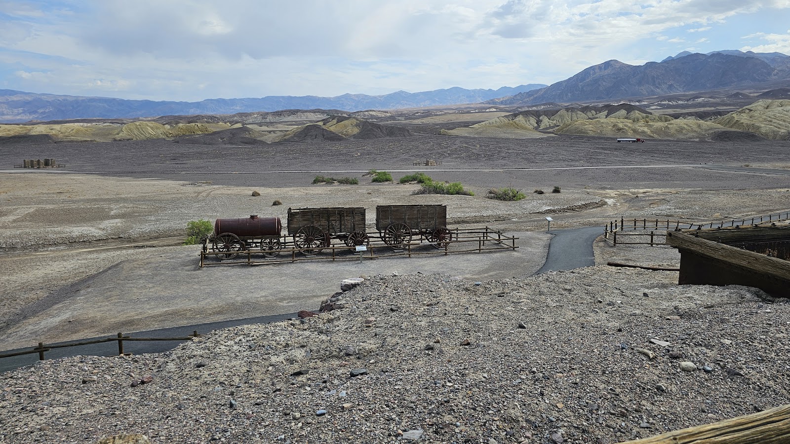
 Only 2-miles down the road from the campsite is the Harmony Borax Works.
 There is a .4-mile interpretive trail that winds you though a borax refining plant.
 This large boiler was used to separate the borax from the rock.


 Once the borax was separated from the rock it was loaded into carts.

 The two loaded carts were then attached to a team of 20 mules...
 ...and 1,200 gallons of drinking water was put in the rear. Those back wheels are all 7' tall.
 Including the mules, the entire train was over 100' long and weighed over 36 tons
 22-miles north of the campground is where you'll find the sand dunes.
 You are permitted to hike anywhere you want out on the dunes...
 ...but they advise to get an early start and be done by 10:00AM in the summer.
 Like so many other places in the park,


 Can you see that white rectangular shape near the top of the mountainside?
 Maybe if we zoom way in on it you'll be able to make it out!
 We were here so early in the morning the signpost was still in shadow from the mountain.
 This puddle is not from any recent rain. There is an underground spring here.
 You can walk as far out on the 15-mile wide salt flat as you wish.
 It pretty hard packed but still get stuck to your shoes.
 If you go far enough out you'll find the untrampled rifts in the salt.
 In this photo you can see the shiny reflective cars in the parking lot

 About a mile off the highway is what's called the Devil's Golf Course.
 Quite honestly I don't understand the name?
 Nor do I get the appeal of the location, but hey, we did give it a visit.

 Artist's Palette is located 5-miles down a 9-mile long 1-way scenic side road.
 All of the multicolored rock faces do make for a beautiful palette of colors.
 We stopped at one trailhead parking area to see what was on the other side of a hill.
 There wasn't one, but rather two, of these deep dips in the road.
 I can see why they restrict this road to vehicles 25' or less.
 That colorful section on the right up ahead is the Artist's Palette stop.
 There are of course the brown, tan and red colors here like the rest of the park...
 ...but here there are blues, greens and oranges too.
 And even a few shades of purple.
 Hiking among the colored rocks is permitted here along a trail.
 The road from this point on is filled with colorful rocks...
 ...and some tight twisting turns. I'm glad ROVER is only 20' long.
 Ah, back to the highway and back to camp.


 If you want to see the Natural Bridge you'll have to drive the 1.5-mile long gravel road...
 ...then begin the 1-mile hike to the bridge.
 The entire trail in done inside of a gravel bottomed canyon.

 It wasn't long before the Natural Bridge comes into view.
 It looks pretty thick and sturdy from this angle.
 It's not until you get up close and underneath that it begins look unstable.

 From the backside it once again looks pretty safe.
 From this angle you can just make out the salt flats and mountains on the valley floor.
 That was well worth the hike, now that we're safely on the other side again.
 It that a small arch I see high up on the left? How did we miss that on the way in?
 Wait just a cotton pickin' minute!?
 That's not an arch at all. It just the sunlight playing tricks on us.
 ROVER is right where we left him.
 Can you spot the wildlife in this photo?
 We just had a coyote run across the road in front of us.

