
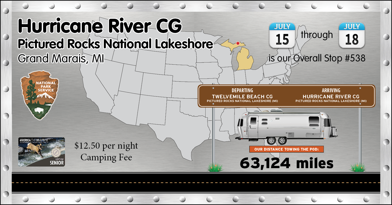

We will still have no cell signal or the ability to use the Starlink dish, but we'll be a little bit closer to the town of Grand Marais (pop. 234).


Soon after getting setup we headed 12-miles east to the town of Grand Marais to eat lunch. Afterwards we headed over to the little town library to begin creating the previous blog post.
It wasn’t long before we left the library because it was unsuitable for my creative juices. In other words, there was no air conditioning, no bathroom and very uncomfortable chairs, little cell signal and slooooow wifi. Needless to say, it was a VERY SMALL town library and after just one hour I was ready to leave.
It wasn’t a total loss heading into town, we did have a nice lunch at the Breakwall Grill and I purchased a Faygo Soda at the gas station next door. Faygo is a Michigan thing, developed near Detroit in 1907 and currently boasts over 50 flavors.

What it takes is to get up at 8:00am and drive 36-miles west, back into Munising, to the “good” library where I can work in air conditioned comfort, sitting in a comfortable chair, with a clean bathroom and super fast wifi.
Of course we arrived much too early, the library opens at 10:00am, so we headed over to Earl E. Byrd’s Cafe to have an enormous breakfast. I knew we selected the right place when we arrived to find a line of people standing outside on the sidewalk waiting for seats.
Everyone else passed on the opportunity for immediate seating at the bar, but not us, I was hungry.
We were at the library when they opened at 10:00am and by 2:00pm I had the blog posted and had time to clear up a few other pages of the website that needed updating.
By 2:30pm we were headed over to Capt’n Ron’s Fish ’N’ Chips for what we were told is the freshest fish in town.

With most of the afternoon and early evening left, we decided to get a few things checked off our sightseeing list. First up was the Lake Superior Overlook, which is located in between the two campgrounds we’ve stayed in.


Back on the road and heading east we went right past our campsite and headed for the Log Slide Scenic Overlook. This one had about a quarter mile hike to the overlook and along the way there was a lean to barn with some old logging equipment.


One last stop for today is at the Grand Sable Lake Overlook where there are several picnic tables and a wide view of the lake with it’s Black Eyed Susan’s in the foreground.

That's enough sigthseeing for today, the rest will have to wait for tomorrow.

Which is why there are a handful of things that NEVER HAPPENED today!
First off we didn't know that the sun would NEVER come out from behind the clouds today. Also the temperature NEVER rose above 60°F and it NEVER stopped raining for more than a few minutes at a time. Also the winds NEVER really dipped below 15MPH today.
All of that made for a pretty miserable day to be outside.
Consequently we NEVER left THE POD all day and we NEVER hiked the 1½-mile trail from our campsite down to the Au Sable Lighthouse, which is the whole reason we moved to this campground in the first place.

THURSDAY - This morning the weather is gorgeous. Thanks to Tricia getting up at 7:00AM and hiking out to the lighthouse, we all, including me, get to see what we almost missed.
AU SABLE LIGHTHOUSE
|
||||||||
 Most of the trail was wide and level...
|
||||||||
 ...and always paralleling just a few feet away from the shoreline
|
||||||||
 There were even a few access points for the beach.
|
||||||||
 I believe she's getting close!
|
||||||||
 Built in 1873-74 the lighthouse is 86' tall with another 23' below the surface.
|
||||||||
 In 1909 the light keepers quarters were expanded to what you see today.
|
||||||||
 In 1968 the lighthouse was equipped with a powerful LED light mounted to the catwalk.
|
||||||||
 These lupines were well lit by the morining sun.
|
||||||||
 Apparently just below the beach sand is more solid rock layers.
|
|
Would you like to be notified of new blog posts?

